Memphis geodata
Memphis (Tennessee) is a seat of a second-order administrative division; located in United States in America/Chicago (GMT-5) time zone. With population of 655,770 people, there are 26 cities with bigger population in this country. Compared to other cities in United States, 74.6% of cities are located further ↑North; 59.1% of cities are located further →East and 72.8% of cities have higher elevation than Memphis. Note1


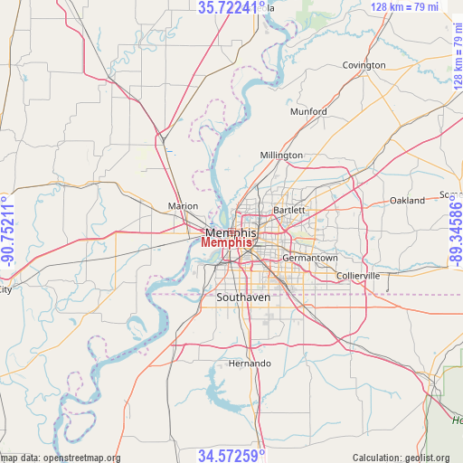
Memphis GPS coordinates[2]
35° 8' 58.308" North, 90° 2' 56.328" West
| Map corner | latitude | longitude |
|---|---|---|
| Upper-left | 35.72241°, | -90.75211° |
| Center: | 35.14953°, | -90.04898° |
| Lower-right: | 34.57259°, | -89.34586° |
| Map W x H: | 127.8×127.8 km | = 79.4×79.4mi |
| max Lat: | 71.29058° ⇑74.6% North |
| Memphis: | 35.14953° |
| min Lat: | ⇓25.4% South 19.06759° |
| min Long | Memphis | max Long |
| -171.73463° | -90.04898° | -66.98998° |
| W 40.9%⇐ | ⇒59.1% E |
Elevation
Elevation of Memphis is 84 m = 276 ft, and this is 210.8 m = 692 ft below average elevation for this country.
| Max E: |
3189 m = 10463 ft | 72.8% |
| Avg. | 294.8 m = 967 ft | |
| Memphis | 84 m = 276 ft | |
Min E: |
-60 m = -197 ft | 27.2% |
See also: Memphis elevation on elevation.city.
Geographical zone
Memphis is located in North temperate zone (between Tropic of Cancer and the Arctic Circle). Distance of this Northern Tropic circle is 1302.3 km =809.2 mi to South.| Distance of | km | miles | from Memphis |
|---|---|---|---|
| North Pole | 6098.8 | 3789.6 | to North |
| Arctic Circle | 3492.9 | 2170.4 | to North |
| Tropic Cancer | 1302.3 | 809.2 | to South |
| Equator | 3908.3 | 2428.5 | to South |


Nearby cities:
15 places around Memphis: (largest is in red/bold)
• Bartlett
17 km =10.6 mi,  68°
68°
• Collierville
37 km =23 mi,  108°
108°
• Germantown
22.8 km =14.2 mi, 107°
• Hernando
36.5 km =22.7 mi,  172°
172°
• Horn Lake
21.6 km =13.4 mi,  176°
176°
• Lakeland
29.5 km =18.3 mi, 72°
• Lynchburg
21.2 km =13.2 mi,  191°
191°
• Marion
15.2 km =9.4 mi,  298°
298°
• Millington
25.4 km =15.8 mi,  32°
32°
• New South Memphis
7 km =4.3 mi, 185°
• Olive Branch
28.9 km =18 mi,  136°
136°
• Southaven
18.2 km =11.3 mi, 169°
• Turrell
31.9 km =19.8 mi,  323°
323°
• Walls
23.3 km =14.5 mi,  203°
203°
• West Memphis
12.3 km =7.6 mi,  268°
268°
Sources, notices
• [Note1] Compared only with cities in United States existing in our database
• [Src1] Map data: © OpenStreetMap contributors (CC-BY-SA)
• [Src2] Other city data from geonames.org with taken over terms of usage.
• [Src3] Geographical zone / Annual Mean Temperature by Robert A. Rohde @ Wikipedia
