Leary geodata
Leary (Georgia) is a populated place; located in United States in America/New_York (GMT-4) time zone. With population of 589 people, there are 19828 cities with bigger population in this country. Compared to other cities in United States, 89.7% of cities are located further ↑North; 57.4% of cities are located further ←West and 76% of cities have higher elevation than Leary. Note1


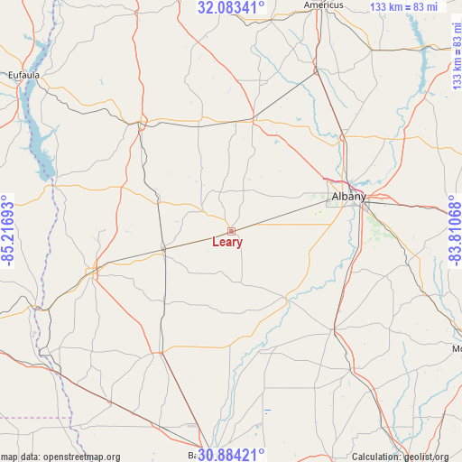
Leary GPS coordinates[2]
31° 29' 8.628" North, 84° 30' 49.68" West
| Map corner | latitude | longitude |
|---|---|---|
| Upper-left | 32.08341°, | -85.21693° |
| Center: | 31.48573°, | -84.5138° |
| Lower-right: | 30.88421°, | -83.81068° |
| Map W x H: | 133.3×133.3 km | = 82.8×82.8mi |
| max Lat: | 71.29058° ⇑89.7% North |
| Leary: | 31.48573° |
| min Lat: | ⇓10.3% South 19.06759° |
| min Long | Leary | max Long |
| -171.73463° | -84.5138° | -66.98998° |
| W 57.4%⇐ | ⇒42.6% E |
Elevation
Elevation of Leary is 66 m = 217 ft, and this is 228.8 m = 751 ft below average elevation for this country.
| Max E: |
3189 m = 10463 ft | 76% |
| Avg. | 294.8 m = 967 ft | |
| Leary | 66 m = 217 ft | |
Min E: |
-60 m = -197 ft | 24% |
See also: United States elevation on elevation.city.
Geographical zone
Leary is located in North temperate zone (between Tropic of Cancer and the Arctic Circle). Distance of this Northern Tropic circle is 895 km =556.1 mi to South.| Distance of | km | miles | from Leary |
|---|---|---|---|
| North Pole | 6506.2 | 4042.8 | to North |
| Arctic Circle | 3900.3 | 2423.5 | to North |
| Tropic Cancer | 895 | 556.1 | to South |
| Equator | 3500.9 | 2175.4 | to South |


Nearby cities:
15 places around Leary: (largest is in red/bold)
• Albany
35.5 km =22.1 mi,  73°
73°
• Arlington
20.7 km =12.9 mi,  255°
255°
• Baconton
35.5 km =22.1 mi,  109°
109°
• Blakely
41.6 km =25.8 mi,  253°
253°
• Camilla
40.4 km =25.1 mi,  134°
134°
• Colquitt
40.7 km =25.3 mi,  210°
210°
• Cuthbert
41.1 km =25.5 mi,  320°
320°
• Dawson
32.6 km =20.3 mi,  11°
11°
• Edison
22.8 km =14.2 mi,  290°
290°
• Leesburg
42.5 km =26.4 mi,  49°
49°
• Morgan
10 km =6.2 mi,  305°
305°
• Newton
25.6 km =15.9 mi,  138°
138°
• Putney
37.6 km =23.4 mi,  92°
92°
• Shellman
31.6 km =19.6 mi,  342°
342°
• Smithville
52.4 km =32.6 mi,  28°
28°
Sources, notices
• [Note1] Compared only with cities in United States existing in our database
• [Src1] Map data: © OpenStreetMap contributors (CC-BY-SA)
• [Src2] Other city data from geonames.org with taken over terms of usage.
• [Src3] Geographical zone / Annual Mean Temperature by Robert A. Rohde @ Wikipedia
