Valley geodata
Valley (Alabama) is a populated place; located in United States in America/Chicago (GMT-5) time zone. With population of 9,464 people, there are 4637 cities with bigger population in this country. Compared to other cities in United States, 85.9% of cities are located further ↑North; 55.4% of cities are located further ←West and 53.9% of cities have higher elevation than Valley. Note1


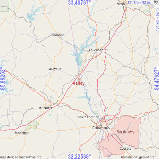
Valley GPS coordinates[2]
32° 49' 7.464" North, 85° 10' 45.804" West
| Map corner | latitude | longitude |
|---|---|---|
| Upper-left | 33.40767°, | -85.88252° |
| Center: | 32.81874°, | -85.17939° |
| Lower-right: | 32.22588°, | -84.47627° |
| Map W x H: | 131.4×131.4 km | = 81.6×81.6mi |
| max Lat: | 71.29058° ⇑85.9% North |
| Valley: | 32.81874° |
| min Lat: | ⇓14.1% South 19.06759° |
| min Long | Valley | max Long |
| -171.73463° | -85.17939° | -66.98998° |
| W 55.4%⇐ | ⇒44.6% E |
Elevation
Elevation of Valley is 184 m = 604 ft, and this is 110.8 m = 364 ft below average elevation for this country.
| Max E: |
3189 m = 10463 ft | 53.9% |
| Avg. | 294.8 m = 967 ft | |
| Valley | 184 m = 604 ft | |
Min E: |
-60 m = -197 ft | 46.1% |
See also: United States elevation on elevation.city.
Geographical zone
Valley is located in North temperate zone (between Tropic of Cancer and the Arctic Circle). Distance of this Northern Tropic circle is 1043.2 km =648.2 mi to South.| Distance of | km | miles | from Valley |
|---|---|---|---|
| North Pole | 6358 | 3950.7 | to North |
| Arctic Circle | 3752.1 | 2331.4 | to North |
| Tropic Cancer | 1043.2 | 648.2 | to South |
| Equator | 3649.1 | 2267.4 | to South |


Nearby cities:
15 places around Valley: (largest is in red/bold)
• Auburn
36.5 km =22.7 mi,  230°
230°
• Bibb City
40 km =24.9 mi,  153°
153°
• Hamilton
29.3 km =18.2 mi,  103°
103°
• Huguley
5 km =3.1 mi,  290°
290°
• LaGrange
28.1 km =17.5 mi,  29°
29°
• Ladonia
40.1 km =24.9 mi,  166°
166°
• Lafayette
22.6 km =14 mi, 293°
• Lanett
5.7 km =3.5 mi,  349°
349°
• Opelika
26.8 km =16.7 mi,  223°
223°
• Phenix City
42.1 km =26.2 mi,  156°
156°
• Pine Mountain
30.8 km =19.1 mi,  80°
80°
• Roanoke
41.1 km =25.5 mi,  334°
334°
• Rock Mills
39.2 km =24.4 mi, 345°
• Smiths Station
31.9 km =19.8 mi, 166°
• West Point
6.6 km =4.1 mi,  356°
356°
Sources, notices
• [Note1] Compared only with cities in United States existing in our database
• [Src1] Map data: © OpenStreetMap contributors (CC-BY-SA)
• [Src2] Other city data from geonames.org with taken over terms of usage.
• [Src3] Geographical zone / Annual Mean Temperature by Robert A. Rohde @ Wikipedia
