LaGrange geodata
LaGrange (Georgia) is a populated place; located in United States in America/New_York (GMT-4) time zone. With population of 29,588 people, there are 1687 cities with bigger population in this country. Compared to other cities in United States, 85% of cities are located further ↑North; 55.8% of cities are located further ←West and 60.7% of cities have lower elevation than LaGrange. Note1


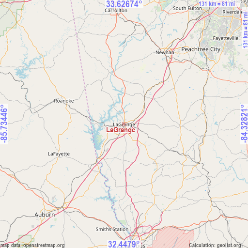
LaGrange GPS coordinates[2]
33° 2' 21.444" North, 85° 1' 52.788" West
| Map corner | latitude | longitude |
|---|---|---|
| Upper-left | 33.62674°, | -85.73446° |
| Center: | 33.03929°, | -85.03133° |
| Lower-right: | 32.4479°, | -84.32821° |
| Map W x H: | 131.1×131.1 km | = 81.5×81.5mi |
| max Lat: | 71.29058° ⇑85% North |
| LaGrange: | 33.03929° |
| min Lat: | ⇓15% South 19.06759° |
| min Long | LaGrange | max Long |
| -171.73463° | -85.03133° | -66.98998° |
| W 55.8%⇐ | ⇒44.2% E |
Elevation
Elevation of LaGrange is 243 m = 797 ft, and this is 51.8 m = 170 ft below average elevation for this country.
| Max E: |
3189 m = 10463 ft | 39.3% |
| Avg. | 294.8 m = 967 ft | |
| LaGrange | 243 m = 797 ft | |
Min E: |
-60 m = -197 ft | 60.7% |
See also: United States elevation on elevation.city.
Geographical zone
LaGrange is located in North temperate zone (between Tropic of Cancer and the Arctic Circle). Distance of this Northern Tropic circle is 1067.7 km =663.4 mi to South.| Distance of | km | miles | from LaGrange |
|---|---|---|---|
| North Pole | 6333.4 | 3935.4 | to North |
| Arctic Circle | 3727.5 | 2316.2 | to North |
| Tropic Cancer | 1067.7 | 663.4 | to South |
| Equator | 3673.6 | 2282.7 | to South |


Nearby cities:
15 places around LaGrange: (largest is in red/bold)
• East Newnan
42 km =26.1 mi,  34°
34°
• Franklin
27.2 km =16.9 mi,  346°
346°
• Grantville
28.4 km =17.6 mi,  39°
39°
• Greenville
29.7 km =18.5 mi,  92°
92°
• Hamilton
34.5 km =21.4 mi,  154°
154°
• Hogansville
18.4 km =11.4 mi, 36°
• Huguley
29.3 km =18.2 mi,  219°
219°
• Lafayette
37.8 km =23.5 mi,  245°
245°
• Lanett
24.1 km =15 mi, 218°
• Luthersville
32.8 km =20.4 mi,  54°
54°
• Pine Mountain
25.5 km =15.8 mi,  139°
139°
• Roanoke
34.1 km =21.2 mi,  291°
291°
• Rock Mills
27.4 km =17 mi,  299°
299°
• Valley
28.1 km =17.5 mi,  209°
209°
• West Point
22.9 km =14.2 mi, 218°
Sources, notices
• [Note1] Compared only with cities in United States existing in our database
• [Src1] Map data: © OpenStreetMap contributors (CC-BY-SA)
• [Src2] Other city data from geonames.org with taken over terms of usage.
• [Src3] Geographical zone / Annual Mean Temperature by Robert A. Rohde @ Wikipedia
