Hogansville geodata
Hogansville (Georgia) is a populated place; located in United States in America/New_York (GMT-4) time zone. With population of 3,110 people, there are 9444 cities with bigger population in this country. Compared to other cities in United States, 84.5% of cities are located further ↑North; 56.1% of cities are located further ←West and 54.2% of cities have lower elevation than Hogansville. Note1


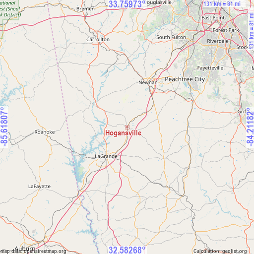
Hogansville GPS coordinates[2]
33° 10' 23.448" North, 84° 54' 53.784" West
| Map corner | latitude | longitude |
|---|---|---|
| Upper-left | 33.75973°, | -85.61807° |
| Center: | 33.17318°, | -84.91494° |
| Lower-right: | 32.58268°, | -84.21182° |
| Map W x H: | 130.9×130.9 km | = 81.3×81.3mi |
| max Lat: | 71.29058° ⇑84.5% North |
| Hogansville: | 33.17318° |
| min Lat: | ⇓15.5% South 19.06759° |
| min Long | Hogansville | max Long |
| -171.73463° | -84.91494° | -66.98998° |
| W 56.1%⇐ | ⇒43.9% E |
Elevation
Elevation of Hogansville is 215 m = 705 ft, and this is 79.8 m = 262 ft below average elevation for this country.
| Max E: |
3189 m = 10463 ft | 45.8% |
| Avg. | 294.8 m = 967 ft | |
| Hogansville | 215 m = 705 ft | |
Min E: |
-60 m = -197 ft | 54.2% |
See also: United States elevation on elevation.city.
Geographical zone
Hogansville is located in North temperate zone (between Tropic of Cancer and the Arctic Circle). Distance of this Northern Tropic circle is 1082.6 km =672.7 mi to South.| Distance of | km | miles | from Hogansville |
|---|---|---|---|
| North Pole | 6318.6 | 3926.2 | to North |
| Arctic Circle | 3712.7 | 2307 | to North |
| Tropic Cancer | 1082.6 | 672.7 | to South |
| Equator | 3688.5 | 2291.9 | to South |


Nearby cities:
15 places around Hogansville: (largest is in red/bold)
• East Newnan
23.6 km =14.7 mi,  33°
33°
• Franklin
20.6 km =12.8 mi,  304°
304°
• Grantville
10.1 km =6.3 mi,  47°
47°
• Greenville
24.7 km =15.3 mi,  130°
130°
• LaGrange
18.4 km =11.4 mi,  216°
216°
• Lanett
42.5 km =26.4 mi, 217°
• Luthersville
16.4 km =10.2 mi,  75°
75°
• Newnan
25.4 km =15.8 mi,  24°
24°
• Peachtree City
38.7 km =24 mi, 50°
• Pine Mountain
34.7 km =21.6 mi,  170°
170°
• Rock Mills
34.7 km =21.6 mi,  267°
267°
• Senoia
36.5 km =22.7 mi,  66°
66°
• West Point
41.3 km =25.7 mi, 217°
• Whitesburg
35.7 km =22.2 mi,  0°
0°
• Woodbury
37.4 km =23.2 mi,  124°
124°
Sources, notices
• [Note1] Compared only with cities in United States existing in our database
• [Src1] Map data: © OpenStreetMap contributors (CC-BY-SA)
• [Src2] Other city data from geonames.org with taken over terms of usage.
• [Src3] Geographical zone / Annual Mean Temperature by Robert A. Rohde @ Wikipedia
