La Grange geodata
La Grange (Missouri) is a populated place; located in United States in America/Chicago (GMT-5) time zone. With population of 939 people, there are 16722 cities with bigger population in this country. Compared to other cities in United States, 54% of cities are located further ↓South; 63.1% of cities are located further →East and 60.9% of cities have higher elevation than La Grange. Note1


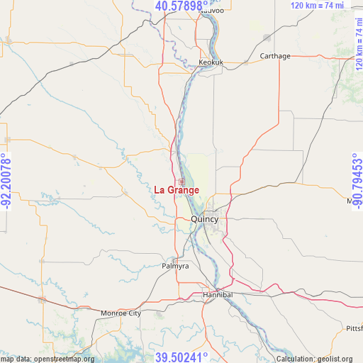
La Grange GPS coordinates[2]
40° 2' 34.152" North, 91° 29' 51.54" West
| Map corner | latitude | longitude |
|---|---|---|
| Upper-left | 40.57898°, | -92.20078° |
| Center: | 40.04282°, | -91.49765° |
| Lower-right: | 39.50241°, | -90.79453° |
| Map W x H: | 119.7×119.7 km | = 74.4×74.4mi |
| max Lat: | 71.29058° ⇑46% North |
| La Grange: | 40.04282° |
| min Lat: | ⇓54% South 19.06759° |
| min Long | La Grange | max Long |
| -171.73463° | -91.49765° | -66.98998° |
| W 36.9%⇐ | ⇒63.1% E |
Elevation
Elevation of La Grange is 150 m = 492 ft, and this is 144.8 m = 475 ft below average elevation for this country.
| Max E: |
3189 m = 10463 ft | 60.9% |
| Avg. | 294.8 m = 967 ft | |
| La Grange | 150 m = 492 ft | |
Min E: |
-60 m = -197 ft | 39.1% |
See also: United States elevation on elevation.city.
Geographical zone
La Grange is located in North temperate zone (between Tropic of Cancer and the Arctic Circle). Distance of this Northern Tropic circle is 1846.4 km =1147.3 mi to South.| Distance of | km | miles | from La Grange |
|---|---|---|---|
| North Pole | 5554.7 | 3451.5 | to North |
| Arctic Circle | 2948.8 | 1832.3 | to North |
| Tropic Cancer | 1846.4 | 1147.3 | to South |
| Equator | 4452.3 | 2766.5 | to South |


Nearby cities:
15 places around La Grange: (largest is in red/bold)
• Camp Point
36.5 km =22.7 mi,  90°
90°
• Canton
14.2 km =8.8 mi,  310°
310°
• Hannibal
39 km =24.2 mi,  162°
162°
• Keokuk
40.6 km =25.2 mi,  13°
13°
• La Belle
36.3 km =22.6 mi,  283°
283°
• Lewistown
27.3 km =17 mi, 280°
• Liberty
37.9 km =23.5 mi,  118°
118°
• Mendon
18.9 km =11.7 mi,  74°
74°
• Monticello
20.1 km =12.5 mi,  294°
294°
• Palmyra
27.7 km =17.2 mi,  184°
184°
• Payson
33.2 km =20.6 mi,  139°
139°
• Quincy
14.1 km =8.8 mi,  147°
147°
• Ursa
11.6 km =7.2 mi, 72°
• Warsaw
35.6 km =22.1 mi, 8°
• Wayland
39.8 km =24.7 mi,  349°
349°
Sources, notices
• [Note1] Compared only with cities in United States existing in our database
• [Src1] Map data: © OpenStreetMap contributors (CC-BY-SA)
• [Src2] Other city data from geonames.org with taken over terms of usage.
• [Src3] Geographical zone / Annual Mean Temperature by Robert A. Rohde @ Wikipedia
