Burlington geodata
Burlington (Kansas) is a seat of a second-order administrative division; located in United States in America/Chicago (GMT-5) time zone. With population of 2,615 people, there are 10366 cities with bigger population in this country. Compared to other cities in United States, 60.7% of cities are located further ↑North; 72.9% of cities are located further →East and 75.7% of cities have lower elevation than Burlington. Note1


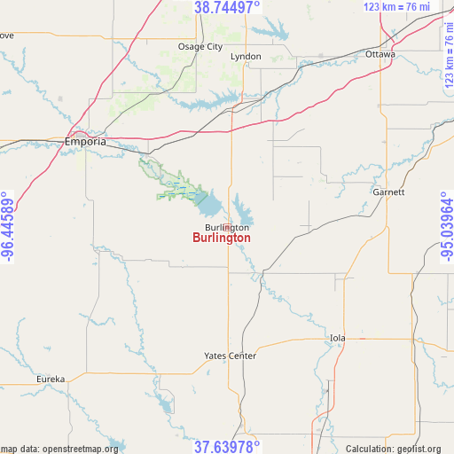
Burlington GPS coordinates[2]
38° 11' 40.092" North, 95° 44' 33.936" West
| Map corner | latitude | longitude |
|---|---|---|
| Upper-left | 38.74497°, | -96.44589° |
| Center: | 38.19447°, | -95.74276° |
| Lower-right: | 37.63978°, | -95.03964° |
| Map W x H: | 122.9×122.9 km | = 76.4×76.4mi |
| max Lat: | 71.29058° ⇑60.7% North |
| Burlington: | 38.19447° |
| min Lat: | ⇓39.3% South 19.06759° |
| min Long | Burlington | max Long |
| -171.73463° | -95.74276° | -66.98998° |
| W 27.1%⇐ | ⇒72.9% E |
Elevation
Elevation of Burlington is 318 m = 1043 ft, and this is 23.2 m = 76 ft above average elevation for this country.
| Max E: |
3189 m = 10463 ft | 24.3% |
| Burlington | 318 m 1043 ft | |
| Avg. | 294.8 m = 967 ft | |
Min E: |
-60 m = -197 ft | 75.7% |
See also: United States elevation on elevation.city.
Geographical zone
Burlington is located in North temperate zone (between Tropic of Cancer and the Arctic Circle). Distance of this Northern Tropic circle is 1640.9 km =1019.6 mi to South.| Distance of | km | miles | from Burlington |
|---|---|---|---|
| North Pole | 5760.2 | 3579.2 | to North |
| Arctic Circle | 3154.3 | 1960 | to North |
| Tropic Cancer | 1640.9 | 1019.6 | to South |
| Equator | 4246.8 | 2638.8 | to South |


Nearby cities:
15 places around Burlington: (largest is in red/bold)
• Emporia
44.8 km =27.8 mi,  301°
301°
• Garnett
44.8 km =27.8 mi,  77°
77°
• Gas
46 km =28.6 mi,  130°
130°
• Humboldt
50.4 km =31.3 mi,  147°
147°
• Iola
42.4 km =26.3 mi,  135°
135°
• La Harpe
49.6 km =30.8 mi, 128°
• LeRoy
15.5 km =9.6 mi, 142°
• Lebo
26.5 km =16.5 mi,  338°
338°
• Lyndon
46.5 km =28.9 mi,  6°
6°
• Madison
35 km =21.7 mi,  259°
259°
• Olpe
37.8 km =23.5 mi,  281°
281°
• Osage City
49.4 km =30.7 mi,  351°
351°
• Pomona
51.3 km =31.9 mi,  29°
29°
• Waverly
25.3 km =15.7 mi, 28°
• Yates Center
34.8 km =21.6 mi,  178°
178°
Sources, notices
• [Note1] Compared only with cities in United States existing in our database
• [Src1] Map data: © OpenStreetMap contributors (CC-BY-SA)
• [Src2] Other city data from geonames.org with taken over terms of usage.
• [Src3] Geographical zone / Annual Mean Temperature by Robert A. Rohde @ Wikipedia
