LeRoy geodata
LeRoy (Kansas) is a populated place; located in United States in America/Chicago (GMT-5) time zone. With population of 548 people, there are 20295 cities with bigger population in this country. Compared to other cities in United States, 61.2% of cities are located further ↑North; 72.7% of cities are located further →East and 74.5% of cities have lower elevation than LeRoy. Note1


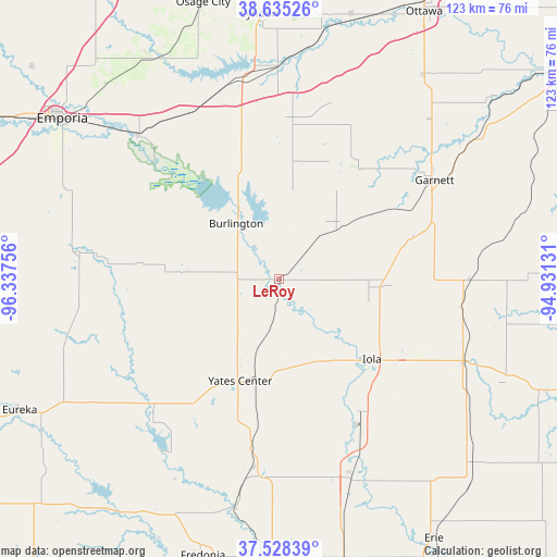
LeRoy GPS coordinates[2]
38° 5' 2.112" North, 95° 38' 3.948" West
| Map corner | latitude | longitude |
|---|---|---|
| Upper-left | 38.63526°, | -96.33756° |
| Center: | 38.08392°, | -95.63443° |
| Lower-right: | 37.52839°, | -94.93131° |
| Map W x H: | 123.1×123.1 km | = 76.5×76.5mi |
| max Lat: | 71.29058° ⇑61.2% North |
| LeRoy: | 38.08392° |
| min Lat: | ⇓38.8% South 19.06759° |
| min Long | LeRoy | max Long |
| -171.73463° | -95.63443° | -66.98998° |
| W 27.3%⇐ | ⇒72.7% E |
Elevation
Elevation of LeRoy is 310 m = 1017 ft, and this is 15.2 m = 50 ft above average elevation for this country.
| Max E: |
3189 m = 10463 ft | 25.5% |
| LeRoy | 310 m 1017 ft | |
| Avg. | 294.8 m = 967 ft | |
Min E: |
-60 m = -197 ft | 74.5% |
See also: United States elevation on elevation.city.
Geographical zone
LeRoy is located in North temperate zone (between Tropic of Cancer and the Arctic Circle). Distance of this Northern Tropic circle is 1628.6 km =1012 mi to South.| Distance of | km | miles | from LeRoy |
|---|---|---|---|
| North Pole | 5772.5 | 3586.9 | to North |
| Arctic Circle | 3166.6 | 1967.6 | to North |
| Tropic Cancer | 1628.6 | 1012 | to South |
| Equator | 4234.5 | 2631.2 | to South |


Nearby cities:
15 places around LeRoy: (largest is in red/bold)
• Burlington
15.5 km =9.6 mi,  322°
322°
• Chanute
47.6 km =29.6 mi,  160°
160°
• Garnett
40.7 km =25.3 mi,  57°
57°
• Gas
30.9 km =19.2 mi,  125°
125°
• Humboldt
35 km =21.7 mi,  150°
150°
• Iola
27.1 km =16.8 mi, 130°
• La Harpe
34.7 km =21.6 mi,  122°
122°
• Lebo
41.6 km =25.8 mi,  332°
332°
• Lyndon
58.7 km =36.5 mi,  355°
355°
• Madison
44.2 km =27.5 mi,  277°
277°
• Moran
44.7 km =27.8 mi,  114°
114°
• Olpe
50.6 km =31.4 mi,  293°
293°
• Pomona
59.1 km =36.7 mi,  15°
15°
• Waverly
34.6 km =21.5 mi,  4°
4°
• Yates Center
24.2 km =15 mi,  201°
201°
Sources, notices
• [Note1] Compared only with cities in United States existing in our database
• [Src1] Map data: © OpenStreetMap contributors (CC-BY-SA)
• [Src2] Other city data from geonames.org with taken over terms of usage.
• [Src3] Geographical zone / Annual Mean Temperature by Robert A. Rohde @ Wikipedia
