Humboldt geodata
Humboldt (Kansas) is a populated place; located in United States in America/Chicago (GMT-5) time zone. With population of 1,856 people, there are 12350 cities with bigger population in this country. Compared to other cities in United States, 62.6% of cities are located further ↑North; 72.2% of cities are located further →East and 73.3% of cities have lower elevation than Humboldt. Note1


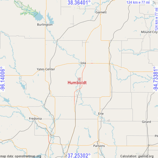
Humboldt GPS coordinates[2]
37° 48' 38.16" North, 95° 26' 12.948" West
| Map corner | latitude | longitude |
|---|---|---|
| Upper-left | 38.36401°, | -96.14006° |
| Center: | 37.8106°, | -95.43693° |
| Lower-right: | 37.25302°, | -94.73381° |
| Map W x H: | 123.5×123.5 km | = 76.7×76.7mi |
| max Lat: | 71.29058° ⇑62.6% North |
| Humboldt: | 37.8106° |
| min Lat: | ⇓37.4% South 19.06759° |
| min Long | Humboldt | max Long |
| -171.73463° | -95.43693° | -66.98998° |
| W 27.8%⇐ | ⇒72.2% E |
Elevation
Elevation of Humboldt is 303 m = 994 ft, and this is 8.2 m = 27 ft above average elevation for this country.
| Max E: |
3189 m = 10463 ft | 26.7% |
| Humboldt | 303 m 994 ft | |
| Avg. | 294.8 m = 967 ft | |
Min E: |
-60 m = -197 ft | 73.3% |
See also: United States elevation on elevation.city.
Geographical zone
Humboldt is located in North temperate zone (between Tropic of Cancer and the Arctic Circle). Distance of this Northern Tropic circle is 1598.2 km =993.1 mi to South.| Distance of | km | miles | from Humboldt |
|---|---|---|---|
| North Pole | 5802.9 | 3605.8 | to North |
| Arctic Circle | 3197 | 1986.5 | to North |
| Tropic Cancer | 1598.2 | 993.1 | to South |
| Equator | 4204.1 | 2612.3 | to South |


Nearby cities:
15 places around Humboldt: (largest is in red/bold)
• Burlington
50.4 km =31.3 mi,  327°
327°
• Chanute
14.7 km =9.1 mi,  186°
186°
• Cherryvale
60.9 km =37.8 mi, 189°
• Erie
31.9 km =19.8 mi,  147°
147°
• Fredonia
46.1 km =28.6 mi,  228°
228°
• Garnett
55 km =34.2 mi,  18°
18°
• Gas
14.9 km =9.3 mi,  32°
32°
• Iola
13.1 km =8.1 mi,  14°
14°
• La Harpe
16.9 km =10.5 mi,  45°
45°
• LeRoy
35 km =21.7 mi, 330°
• Moran
26.2 km =16.3 mi,  63°
63°
• Neodesha
48.6 km =30.2 mi,  206°
206°
• Parsons
54.5 km =33.9 mi,  163°
163°
• Saint Paul
39.9 km =24.8 mi,  144°
144°
• Yates Center
27.2 km =16.9 mi,  286°
286°
Sources, notices
• [Note1] Compared only with cities in United States existing in our database
• [Src1] Map data: © OpenStreetMap contributors (CC-BY-SA)
• [Src2] Other city data from geonames.org with taken over terms of usage.
• [Src3] Geographical zone / Annual Mean Temperature by Robert A. Rohde @ Wikipedia
