Iola geodata
Iola (Kansas) is a seat of a second-order administrative division; located in United States in America/Chicago (GMT-5) time zone. With population of 5,470 people, there are 6786 cities with bigger population in this country. Compared to other cities in United States, 62.1% of cities are located further ↑North; 72.1% of cities are located further →East and 72.6% of cities have lower elevation than Iola. Note1


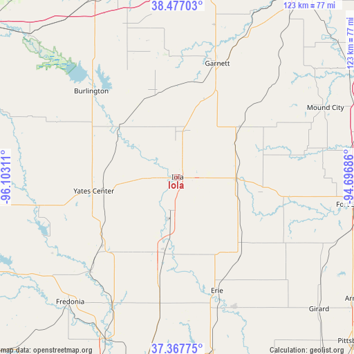
Iola GPS coordinates[2]
37° 55' 28.128" North, 95° 23' 59.928" West
| Map corner | latitude | longitude |
|---|---|---|
| Upper-left | 38.47703°, | -96.10311° |
| Center: | 37.92448°, | -95.39998° |
| Lower-right: | 37.36775°, | -94.69686° |
| Map W x H: | 123.3×123.3 km | = 76.6×76.6mi |
| max Lat: | 71.29058° ⇑62.1% North |
| Iola: | 37.92448° |
| min Lat: | ⇓37.9% South 19.06759° |
| min Long | Iola | max Long |
| -171.73463° | -95.39998° | -66.98998° |
| W 27.9%⇐ | ⇒72.1% E |
Elevation
Elevation of Iola is 299 m = 981 ft, and this is 4.2 m = 14 ft above average elevation for this country.
| Max E: |
3189 m = 10463 ft | 27.4% |
| Iola | 299 m 981 ft | |
| Avg. | 294.8 m = 967 ft | |
Min E: |
-60 m = -197 ft | 72.6% |
See also: United States elevation on elevation.city.
Geographical zone
Iola is located in North temperate zone (between Tropic of Cancer and the Arctic Circle). Distance of this Northern Tropic circle is 1610.9 km =1001 mi to South.| Distance of | km | miles | from Iola |
|---|---|---|---|
| North Pole | 5790.3 | 3597.9 | to North |
| Arctic Circle | 3184.4 | 1978.7 | to North |
| Tropic Cancer | 1610.9 | 1001 | to South |
| Equator | 4216.8 | 2620.2 | to South |


Nearby cities:
15 places around Iola: (largest is in red/bold)
• Burlington
42.4 km =26.3 mi,  315°
315°
• Chanute
27.7 km =17.2 mi,  190°
190°
• Erie
42 km =26.1 mi,  160°
160°
• Fort Scott
61.4 km =38.2 mi,  98°
98°
• Fredonia
57.4 km =35.7 mi,  220°
220°
• Garnett
41.9 km =26 mi,  19°
19°
• Gas
4.7 km =2.9 mi,  91°
91°
• Humboldt
13.1 km =8.1 mi, 194°
• La Harpe
8.9 km =5.5 mi, 95°
• LeRoy
27.1 km =16.8 mi,  310°
310°
• Moran
20.2 km =12.6 mi, 92°
• Mound City
56.8 km =35.3 mi,  64°
64°
• Saint Paul
49.3 km =30.6 mi, 156°
• Waverly
55.1 km =34.2 mi,  341°
341°
• Yates Center
29.6 km =18.4 mi,  260°
260°
Sources, notices
• [Note1] Compared only with cities in United States existing in our database
• [Src1] Map data: © OpenStreetMap contributors (CC-BY-SA)
• [Src2] Other city data from geonames.org with taken over terms of usage.
• [Src3] Geographical zone / Annual Mean Temperature by Robert A. Rohde @ Wikipedia
