Pembroke geodata
Pembroke (Kentucky) is a populated place; located in United States in America/Chicago (GMT-5) time zone. With population of 889 people, there are 17051 cities with bigger population in this country. Compared to other cities in United States, 67% of cities are located further ↑North; 50.5% of cities are located further →East and 56% of cities have higher elevation than Pembroke. Note1


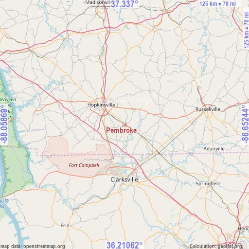
Pembroke GPS coordinates[2]
36° 46' 33.168" North, 87° 21' 20.016" West
| Map corner | latitude | longitude |
|---|---|---|
| Upper-left | 37.337°, | -88.05869° |
| Center: | 36.77588°, | -87.35556° |
| Lower-right: | 36.21062°, | -86.65244° |
| Map W x H: | 125.2×125.2 km | = 77.8×77.8mi |
| max Lat: | 71.29058° ⇑67% North |
| Pembroke: | 36.77588° |
| min Lat: | ⇓33% South 19.06759° |
| min Long | Pembroke | max Long |
| -171.73463° | -87.35556° | -66.98998° |
| W 49.5%⇐ | ⇒50.5% E |
Elevation
Elevation of Pembroke is 176 m = 577 ft, and this is 118.8 m = 390 ft below average elevation for this country.
| Max E: |
3189 m = 10463 ft | 56% |
| Avg. | 294.8 m = 967 ft | |
| Pembroke | 176 m = 577 ft | |
Min E: |
-60 m = -197 ft | 44% |
See also: United States elevation on elevation.city.
Geographical zone
Pembroke is located in North temperate zone (between Tropic of Cancer and the Arctic Circle). Distance of this Northern Tropic circle is 1483.2 km =921.6 mi to South.| Distance of | km | miles | from Pembroke |
|---|---|---|---|
| North Pole | 5918 | 3677.3 | to North |
| Arctic Circle | 3312.1 | 2058 | to North |
| Tropic Cancer | 1483.2 | 921.6 | to South |
| Equator | 4089.1 | 2540.8 | to South |


Nearby cities:
15 places around Pembroke: (largest is in red/bold)
• Adairville
46.5 km =28.9 mi,  105°
105°
• Adams
33.6 km =20.9 mi,  129°
129°
• Cadiz
43.8 km =27.2 mi,  283°
283°
• Clarksville
27.4 km =17 mi,  180°
180°
• Crofton
32.4 km =20.1 mi,  339°
339°
• Elkton
18.3 km =11.4 mi,  78°
78°
• Fort Campbell North
16.4 km =10.2 mi,  214°
214°
• Greenville
49.8 km =30.9 mi,  18°
18°
• Guthrie
22 km =13.7 mi, 130°
• Hopkinsville
15.7 km =9.8 mi,  309°
309°
• Lewisburg
43.2 km =26.8 mi,  57°
57°
• Nortonville
46.9 km =29.1 mi,  349°
349°
• Oak Grove
14.6 km =9.1 mi, 212°
• Russellville
42.4 km =26.3 mi, 79°
• White Plains
45.4 km =28.2 mi,  356°
356°
Sources, notices
• [Note1] Compared only with cities in United States existing in our database
• [Src1] Map data: © OpenStreetMap contributors (CC-BY-SA)
• [Src2] Other city data from geonames.org with taken over terms of usage.
• [Src3] Geographical zone / Annual Mean Temperature by Robert A. Rohde @ Wikipedia
