Russellville geodata
Russellville (Kentucky) is a seat of a second-order administrative division; located in United States in America/Chicago (GMT-5) time zone. With population of 7,056 people, there are 5778 cities with bigger population in this country. Compared to other cities in United States, 66.8% of cities are located further ↑North; 50.5% of cities are located further ←West and 53.6% of cities have higher elevation than Russellville. Note1


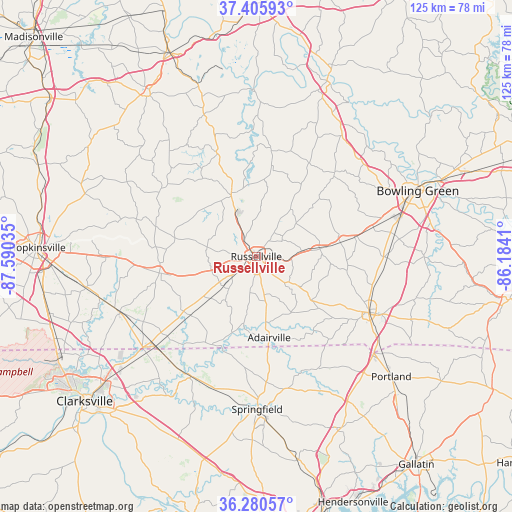
Russellville GPS coordinates[2]
36° 50' 43.152" North, 86° 53' 13.992" West
| Map corner | latitude | longitude |
|---|---|---|
| Upper-left | 37.40593°, | -87.59035° |
| Center: | 36.84532°, | -86.88722° |
| Lower-right: | 36.28057°, | -86.1841° |
| Map W x H: | 125.1×125.1 km | = 77.7×77.7mi |
| max Lat: | 71.29058° ⇑66.8% North |
| Russellville: | 36.84532° |
| min Lat: | ⇓33.2% South 19.06759° |
| min Long | Russellville | max Long |
| -171.73463° | -86.88722° | -66.98998° |
| W 50.5%⇐ | ⇒49.5% E |
Elevation
Elevation of Russellville is 185 m = 607 ft, and this is 109.8 m = 360 ft below average elevation for this country.
| Max E: |
3189 m = 10463 ft | 53.6% |
| Avg. | 294.8 m = 967 ft | |
| Russellville | 185 m = 607 ft | |
Min E: |
-60 m = -197 ft | 46.4% |
See also: United States elevation on elevation.city.
Geographical zone
Russellville is located in North temperate zone (between Tropic of Cancer and the Arctic Circle). Distance of this Northern Tropic circle is 1490.9 km =926.4 mi to South.| Distance of | km | miles | from Russellville |
|---|---|---|---|
| North Pole | 5910.2 | 3672.4 | to North |
| Arctic Circle | 3304.4 | 2053.3 | to North |
| Tropic Cancer | 1490.9 | 926.4 | to South |
| Equator | 4096.8 | 2545.6 | to South |


Nearby cities:
15 places around Russellville: (largest is in red/bold)
• Adairville
20 km =12.4 mi,  170°
170°
• Adams
33.3 km =20.7 mi,  208°
208°
• Auburn
15.9 km =9.9 mi,  82°
82°
• Beechmont
38.8 km =24.1 mi,  340°
340°
• Bowling Green
42.6 km =26.5 mi,  67°
67°
• Cross Plains
37.1 km =23.1 mi,  152°
152°
• Drakesboro
43.8 km =27.2 mi, 340°
• Elkton
24.1 km =15 mi,  260°
260°
• Franklin
30.8 km =19.1 mi,  116°
116°
• Guthrie
33.1 km =20.6 mi,  228°
228°
• Lewisburg
16.6 km =10.3 mi, 341°
• Orlinda
31.1 km =19.3 mi, 150°
• Pembroke
42.4 km =26.3 mi, 259°
• Plano
41.9 km =26 mi, 84°
• Springfield
37.4 km =23.2 mi,  179°
179°
Sources, notices
• [Note1] Compared only with cities in United States existing in our database
• [Src1] Map data: © OpenStreetMap contributors (CC-BY-SA)
• [Src2] Other city data from geonames.org with taken over terms of usage.
• [Src3] Geographical zone / Annual Mean Temperature by Robert A. Rohde @ Wikipedia
