Elkton geodata
Elkton (Kentucky) is a seat of a second-order administrative division; located in United States in America/Chicago (GMT-5) time zone. With population of 2,175 people, there are 11403 cities with bigger population in this country. Compared to other cities in United States, 66.9% of cities are located further ↑North; 50% of cities are located further ←West and 52.2% of cities have higher elevation than Elkton. Note1


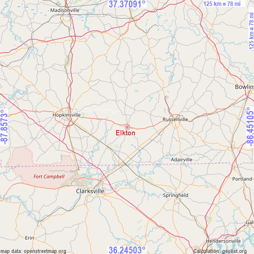
Elkton GPS coordinates[2]
36° 48' 36.144" North, 87° 9' 15.012" West
| Map corner | latitude | longitude |
|---|---|---|
| Upper-left | 37.37091°, | -87.8573° |
| Center: | 36.81004°, | -87.15417° |
| Lower-right: | 36.24503°, | -86.45105° |
| Map W x H: | 125.2×125.2 km | = 77.8×77.8mi |
| max Lat: | 71.29058° ⇑66.9% North |
| Elkton: | 36.81004° |
| min Lat: | ⇓33.1% South 19.06759° |
| min Long | Elkton | max Long |
| -171.73463° | -87.15417° | -66.98998° |
| W 50%⇐ | ⇒50% E |
Elevation
Elevation of Elkton is 190 m = 623 ft, and this is 104.8 m = 344 ft below average elevation for this country.
| Max E: |
3189 m = 10463 ft | 52.2% |
| Avg. | 294.8 m = 967 ft | |
| Elkton | 190 m = 623 ft | |
Min E: |
-60 m = -197 ft | 47.8% |
See also: United States elevation on elevation.city.
Geographical zone
Elkton is located in North temperate zone (between Tropic of Cancer and the Arctic Circle). Distance of this Northern Tropic circle is 1487 km =924 mi to South.| Distance of | km | miles | from Elkton |
|---|---|---|---|
| North Pole | 5914.2 | 3674.9 | to North |
| Arctic Circle | 3308.3 | 2055.7 | to North |
| Tropic Cancer | 1487 | 924 | to South |
| Equator | 4092.9 | 2543.2 | to South |


Nearby cities:
15 places around Elkton: (largest is in red/bold)
• Adairville
31.2 km =19.4 mi,  120°
120°
• Adams
26.5 km =16.5 mi,  162°
162°
• Auburn
40 km =24.9 mi,  81°
81°
• Beechmont
41.9 km =26 mi,  14°
14°
• Clarksville
36.1 km =22.4 mi,  210°
210°
• Crofton
39.5 km =24.5 mi,  311°
311°
• Fort Campbell North
32.3 km =20.1 mi,  237°
237°
• Greenville
43.5 km =27 mi,  357°
357°
• Guthrie
18 km =11.2 mi,  183°
183°
• Hopkinsville
30.6 km =19 mi,  281°
281°
• Lewisburg
26.9 km =16.7 mi,  43°
43°
• Oak Grove
30.4 km =18.9 mi, 237°
• Pembroke
18.3 km =11.4 mi,  258°
258°
• Russellville
24.1 km =15 mi, 80°
• Springfield
41.2 km =25.6 mi,  144°
144°
Sources, notices
• [Note1] Compared only with cities in United States existing in our database
• [Src1] Map data: © OpenStreetMap contributors (CC-BY-SA)
• [Src2] Other city data from geonames.org with taken over terms of usage.
• [Src3] Geographical zone / Annual Mean Temperature by Robert A. Rohde @ Wikipedia
