Guthrie geodata
Guthrie (Kentucky) is a populated place; located in United States in America/Chicago (GMT-5) time zone. With population of 1,437 people, there are 13932 cities with bigger population in this country. Compared to other cities in United States, 67.5% of cities are located further ↑North; 50.1% of cities are located further →East and 57.5% of cities have higher elevation than Guthrie. Note1


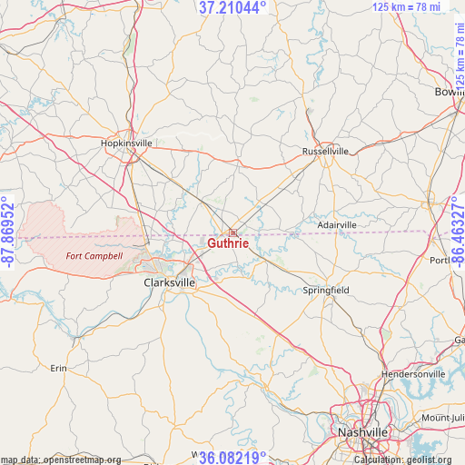
Guthrie GPS coordinates[2]
36° 38' 54.168" North, 87° 9' 59.004" West
| Map corner | latitude | longitude |
|---|---|---|
| Upper-left | 37.21044°, | -87.86952° |
| Center: | 36.64838°, | -87.16639° |
| Lower-right: | 36.08219°, | -86.46327° |
| Map W x H: | 125.4×125.4 km | = 77.9×77.9mi |
| max Lat: | 71.29058° ⇑67.5% North |
| Guthrie: | 36.64838° |
| min Lat: | ⇓32.5% South 19.06759° |
| min Long | Guthrie | max Long |
| -171.73463° | -87.16639° | -66.98998° |
| W 49.9%⇐ | ⇒50.1% E |
Elevation
Elevation of Guthrie is 168 m = 551 ft, and this is 126.8 m = 416 ft below average elevation for this country.
| Max E: |
3189 m = 10463 ft | 57.5% |
| Avg. | 294.8 m = 967 ft | |
| Guthrie | 168 m = 551 ft | |
Min E: |
-60 m = -197 ft | 42.5% |
See also: United States elevation on elevation.city.
Geographical zone
Guthrie is located in North temperate zone (between Tropic of Cancer and the Arctic Circle). Distance of this Northern Tropic circle is 1469 km =912.8 mi to South.| Distance of | km | miles | from Guthrie |
|---|---|---|---|
| North Pole | 5932.1 | 3686 | to North |
| Arctic Circle | 3326.3 | 2066.9 | to North |
| Tropic Cancer | 1469 | 912.8 | to South |
| Equator | 4074.9 | 2532 | to South |


Nearby cities:
15 places around Guthrie: (largest is in red/bold)
• Adairville
28.1 km =17.5 mi,  85°
85°
• Adams
11.6 km =7.2 mi,  129°
129°
• Clarksville
21.7 km =13.5 mi,  232°
232°
• Coopertown
29.4 km =18.3 mi,  142°
142°
• Elkton
18 km =11.2 mi,  3°
3°
• Fort Campbell North
26.2 km =16.3 mi,  271°
271°
• Greenbrier
40.6 km =25.2 mi, 127°
• Hopkinsville
37.7 km =23.4 mi,  309°
309°
• Lewisburg
42.3 km =26.3 mi,  27°
27°
• Oak Grove
24.7 km =15.3 mi, 274°
• Orlinda
40.5 km =25.2 mi,  97°
97°
• Pembroke
22 km =13.7 mi, 310°
• Pleasant View
30.5 km =19 mi,  157°
157°
• Russellville
33.1 km =20.6 mi,  48°
48°
• Springfield
29.5 km =18.3 mi,  121°
121°
Sources, notices
• [Note1] Compared only with cities in United States existing in our database
• [Src1] Map data: © OpenStreetMap contributors (CC-BY-SA)
• [Src2] Other city data from geonames.org with taken over terms of usage.
• [Src3] Geographical zone / Annual Mean Temperature by Robert A. Rohde @ Wikipedia
