Plano geodata
Plano (Kentucky) is a populated place; located in United States in America/Chicago (GMT-5) time zone. With population of 1,117 people, there are 15584 cities with bigger population in this country. Compared to other cities in United States, 66.7% of cities are located further ↑North; 51.8% of cities are located further ←West and 53.3% of cities have higher elevation than Plano. Note1


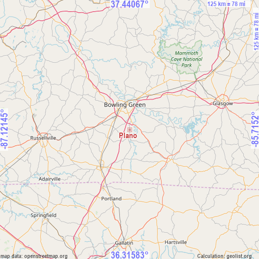
Plano GPS coordinates[2]
36° 52' 49.152" North, 86° 25' 5.952" West
| Map corner | latitude | longitude |
|---|---|---|
| Upper-left | 37.44067°, | -87.12145° |
| Center: | 36.88032°, | -86.41832° |
| Lower-right: | 36.31583°, | -85.7152° |
| Map W x H: | 125.1×125.1 km | = 77.7×77.7mi |
| max Lat: | 71.29058° ⇑66.7% North |
| Plano: | 36.88032° |
| min Lat: | ⇓33.3% South 19.06759° |
| min Long | Plano | max Long |
| -171.73463° | -86.41832° | -66.98998° |
| W 51.8%⇐ | ⇒48.2% E |
Elevation
Elevation of Plano is 186 m = 610 ft, and this is 108.8 m = 357 ft below average elevation for this country.
| Max E: |
3189 m = 10463 ft | 53.3% |
| Avg. | 294.8 m = 967 ft | |
| Plano | 186 m = 610 ft | |
Min E: |
-60 m = -197 ft | 46.7% |
See also: United States elevation on elevation.city.
Geographical zone
Plano is located in North temperate zone (between Tropic of Cancer and the Arctic Circle). Distance of this Northern Tropic circle is 1494.8 km =928.8 mi to South.| Distance of | km | miles | from Plano |
|---|---|---|---|
| North Pole | 5906.4 | 3670.1 | to North |
| Arctic Circle | 3300.5 | 2050.8 | to North |
| Tropic Cancer | 1494.8 | 928.8 | to South |
| Equator | 4100.7 | 2548.1 | to South |


Nearby cities:
15 places around Plano: (largest is in red/bold)
• Adairville
45.3 km =28.1 mi,  238°
238°
• Auburn
26 km =16.2 mi,  266°
266°
• Bowling Green
12.4 km =7.7 mi,  349°
349°
• Brownsville
37.2 km =23.1 mi,  21°
21°
• Cross Plains
44.4 km =27.6 mi,  213°
213°
• Franklin
22.6 km =14 mi,  218°
218°
• Glasgow
46.8 km =29.1 mi,  74°
74°
• Morgantown
45 km =28 mi,  328°
328°
• Orlinda
40.9 km =25.4 mi, 220°
• Park City
40.7 km =25.3 mi,  54°
54°
• Portland
34.3 km =21.3 mi,  194°
194°
• Russellville
41.9 km =26 mi,  264°
264°
• Scottsville
24.7 km =15.3 mi,  124°
124°
• Smiths Grove
26.8 km =16.7 mi,  44°
44°
• Westmoreland
38.5 km =23.9 mi,  156°
156°
Sources, notices
• [Note1] Compared only with cities in United States existing in our database
• [Src1] Map data: © OpenStreetMap contributors (CC-BY-SA)
• [Src2] Other city data from geonames.org with taken over terms of usage.
• [Src3] Geographical zone / Annual Mean Temperature by Robert A. Rohde @ Wikipedia
