Scottsville geodata
Scottsville (Kentucky) is a seat of a second-order administrative division; located in United States in America/Chicago (GMT-5) time zone. With population of 4,411 people, there are 7738 cities with bigger population in this country. Compared to other cities in United States, 67.1% of cities are located further ↑North; 52.4% of cities are located further ←West and 58.2% of cities have lower elevation than Scottsville. Note1


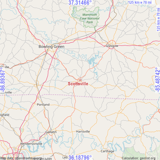
Scottsville GPS coordinates[2]
36° 45' 12.168" North, 86° 11' 25.944" West
| Map corner | latitude | longitude |
|---|---|---|
| Upper-left | 37.31466°, | -86.89367° |
| Center: | 36.75338°, | -86.19054° |
| Lower-right: | 36.18796°, | -85.48742° |
| Map W x H: | 125.3×125.3 km | = 77.9×77.9mi |
| max Lat: | 71.29058° ⇑67.1% North |
| Scottsville: | 36.75338° |
| min Lat: | ⇓32.9% South 19.06759° |
| min Long | Scottsville | max Long |
| -171.73463° | -86.19054° | -66.98998° |
| W 52.4%⇐ | ⇒47.6% E |
Elevation
Elevation of Scottsville is 231 m = 758 ft, and this is 63.8 m = 209 ft below average elevation for this country.
| Max E: |
3189 m = 10463 ft | 41.8% |
| Avg. | 294.8 m = 967 ft | |
| Scottsville | 231 m = 758 ft | |
Min E: |
-60 m = -197 ft | 58.2% |
See also: United States elevation on elevation.city.
Geographical zone
Scottsville is located in North temperate zone (between Tropic of Cancer and the Arctic Circle). Distance of this Northern Tropic circle is 1480.7 km =920.1 mi to South.| Distance of | km | miles | from Scottsville |
|---|---|---|---|
| North Pole | 5920.5 | 3678.8 | to North |
| Arctic Circle | 3314.6 | 2059.6 | to North |
| Tropic Cancer | 1480.7 | 920.1 | to South |
| Equator | 4086.6 | 2539.3 | to South |


Nearby cities:
15 places around Scottsville: (largest is in red/bold)
• Bowling Green
34.7 km =21.6 mi,  319°
319°
• Castalian Springs
41.4 km =25.7 mi,  194°
194°
• Cave City
47.4 km =29.5 mi,  25°
25°
• Franklin
34.6 km =21.5 mi,  264°
264°
• Gallatin
46.6 km =29 mi,  209°
209°
• Glasgow
36.6 km =22.7 mi,  42°
42°
• Hartsville
40.4 km =25.1 mi,  177°
177°
• Lafayette
29.7 km =18.5 mi,  150°
150°
• Park City
40 km =24.9 mi,  18°
18°
• Plano
24.7 km =15.3 mi,  304°
304°
• Portland
34.8 km =21.6 mi,  236°
236°
• Red Boiling Springs
39 km =24.2 mi,  128°
128°
• Smiths Grove
33.3 km =20.7 mi,  357°
357°
• Tompkinsville
44.8 km =27.8 mi,  97°
97°
• Westmoreland
21.9 km =13.6 mi, 193°
Sources, notices
• [Note1] Compared only with cities in United States existing in our database
• [Src1] Map data: © OpenStreetMap contributors (CC-BY-SA)
• [Src2] Other city data from geonames.org with taken over terms of usage.
• [Src3] Geographical zone / Annual Mean Temperature by Robert A. Rohde @ Wikipedia
