Westmoreland geodata
Westmoreland (Tennessee) is a populated place; located in United States in America/Chicago (GMT-5) time zone. With population of 2,291 people, there are 11101 cities with bigger population in this country. Compared to other cities in United States, 67.9% of cities are located further ↑North; 52.2% of cities are located further ←West and 69.5% of cities have lower elevation than Westmoreland. Note1


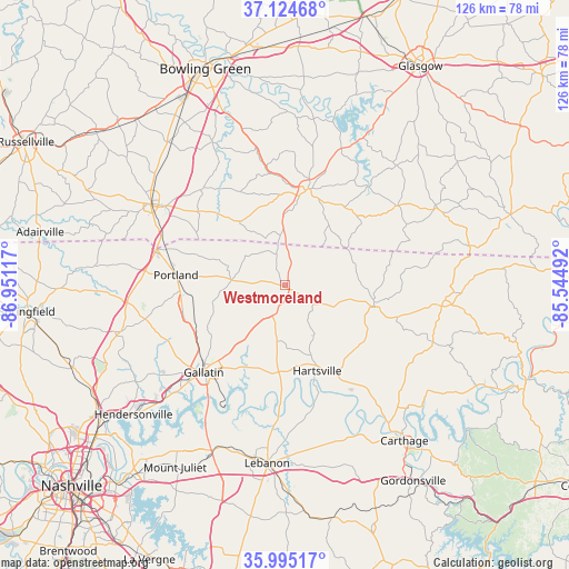
Westmoreland GPS coordinates[2]
36° 33' 43.164" North, 86° 14' 52.944" West
| Map corner | latitude | longitude |
|---|---|---|
| Upper-left | 37.12468°, | -86.95117° |
| Center: | 36.56199°, | -86.24804° |
| Lower-right: | 35.99517°, | -85.54492° |
| Map W x H: | 125.6×125.6 km | = 78×78mi |
| max Lat: | 71.29058° ⇑67.9% North |
| Westmoreland: | 36.56199° |
| min Lat: | ⇓32.1% South 19.06759° |
| min Long | Westmoreland | max Long |
| -171.73463° | -86.24804° | -66.98998° |
| W 52.2%⇐ | ⇒47.8% E |
Elevation
Elevation of Westmoreland is 283 m = 928 ft, and this is 11.8 m = 39 ft below average elevation for this country.
| Max E: |
3189 m = 10463 ft | 30.5% |
| Avg. | 294.8 m = 967 ft | |
| Westmoreland | 283 m = 928 ft | |
Min E: |
-60 m = -197 ft | 69.5% |
See also: United States elevation on elevation.city.
Geographical zone
Westmoreland is located in North temperate zone (between Tropic of Cancer and the Arctic Circle). Distance of this Northern Tropic circle is 1459.4 km =906.8 mi to South.| Distance of | km | miles | from Westmoreland |
|---|---|---|---|
| North Pole | 5941.7 | 3692 | to North |
| Arctic Circle | 3335.9 | 2072.8 | to North |
| Tropic Cancer | 1459.4 | 906.8 | to South |
| Equator | 4065.3 | 2526.1 | to South |


Nearby cities:
15 places around Westmoreland: (largest is in red/bold)
• Castalian Springs
19.5 km =12.1 mi,  195°
195°
• Cross Plains
40 km =24.9 mi,  267°
267°
• Franklin
34.4 km =21.4 mi,  301°
301°
• Gallatin
26.2 km =16.3 mi,  222°
222°
• Hartsville
20.4 km =12.7 mi,  159°
159°
• Lafayette
20.3 km =12.6 mi,  102°
102°
• Lebanon
39.5 km =24.5 mi,  185°
185°
• Orlinda
42.1 km =26.2 mi,  275°
275°
• Plano
38.5 km =23.9 mi,  336°
336°
• Portland
24.1 km =15 mi, 275°
• Red Boiling Springs
35.7 km =22.2 mi, 95°
• Scottsville
21.9 km =13.6 mi,  13°
13°
• Shackle Island
39.2 km =24.4 mi,  237°
237°
• Walnut Grove
33.7 km =20.9 mi,  255°
255°
• White House
37.5 km =23.3 mi,  254°
254°
Sources, notices
• [Note1] Compared only with cities in United States existing in our database
• [Src1] Map data: © OpenStreetMap contributors (CC-BY-SA)
• [Src2] Other city data from geonames.org with taken over terms of usage.
• [Src3] Geographical zone / Annual Mean Temperature by Robert A. Rohde @ Wikipedia
