Hartsville geodata
Hartsville (Tennessee) is a seat of a second-order administrative division; located in United States in America/Chicago (GMT-5) time zone. With population of 2,435 people, there are 10774 cities with bigger population in this country. Compared to other cities in United States, 68.5% of cities are located further ↑North; 52.4% of cities are located further ←West and 61.1% of cities have higher elevation than Hartsville. Note1


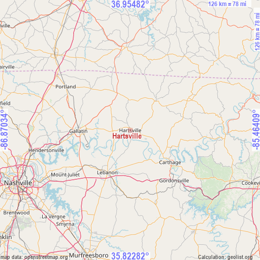
Hartsville GPS coordinates[2]
36° 23' 27.168" North, 86° 10' 1.956" West
| Map corner | latitude | longitude |
|---|---|---|
| Upper-left | 36.95482°, | -86.87034° |
| Center: | 36.39088°, | -86.16721° |
| Lower-right: | 35.82282°, | -85.46409° |
| Map W x H: | 125.9×125.9 km | = 78.2×78.2mi |
| max Lat: | 71.29058° ⇑68.5% North |
| Hartsville: | 36.39088° |
| min Lat: | ⇓31.5% South 19.06759° |
| min Long | Hartsville | max Long |
| -171.73463° | -86.16721° | -66.98998° |
| W 52.4%⇐ | ⇒47.6% E |
Elevation
Elevation of Hartsville is 149 m = 489 ft, and this is 145.8 m = 478 ft below average elevation for this country.
| Max E: |
3189 m = 10463 ft | 61.1% |
| Avg. | 294.8 m = 967 ft | |
| Hartsville | 149 m = 489 ft | |
Min E: |
-60 m = -197 ft | 38.9% |
See also: United States elevation on elevation.city.
Geographical zone
Hartsville is located in North temperate zone (between Tropic of Cancer and the Arctic Circle). Distance of this Northern Tropic circle is 1440.4 km =895 mi to South.| Distance of | km | miles | from Hartsville |
|---|---|---|---|
| North Pole | 5960.8 | 3703.9 | to North |
| Arctic Circle | 3354.9 | 2084.6 | to North |
| Tropic Cancer | 1440.4 | 895 | to South |
| Equator | 4046.3 | 2514.3 | to South |


Nearby cities:
15 places around Hartsville: (largest is in red/bold)
• Alexandria
36.8 km =22.9 mi,  160°
160°
• Carthage
24.7 km =15.3 mi,  128°
128°
• Castalian Springs
12.6 km =7.8 mi,  271°
271°
• Gallatin
25 km =15.5 mi, 269°
• Gordonsville
32.3 km =20.1 mi,  138°
138°
• Green Hill
39 km =24.2 mi,  241°
241°
• Lafayette
19.2 km =11.9 mi,  41°
41°
• Lebanon
23.2 km =14.4 mi,  208°
208°
• Mount Juliet
38 km =23.6 mi, 236°
• Portland
37.7 km =23.4 mi,  304°
304°
• Red Boiling Springs
32.5 km =20.2 mi,  60°
60°
• Shackle Island
40.3 km =25 mi, 266°
• South Carthage
25.4 km =15.8 mi, 130°
• Watertown
32.5 km =20.2 mi,  174°
174°
• Westmoreland
20.4 km =12.7 mi,  339°
339°
Sources, notices
• [Note1] Compared only with cities in United States existing in our database
• [Src1] Map data: © OpenStreetMap contributors (CC-BY-SA)
• [Src2] Other city data from geonames.org with taken over terms of usage.
• [Src3] Geographical zone / Annual Mean Temperature by Robert A. Rohde @ Wikipedia
