Logansport geodata
Logansport (Louisiana) is a populated place; located in United States in America/Chicago (GMT-5) time zone. With population of 1,564 people, there are 13425 cities with bigger population in this country. Compared to other cities in United States, 88.6% of cities are located further ↑North; 68.6% of cities are located further →East and 75.1% of cities have higher elevation than Logansport. Note1


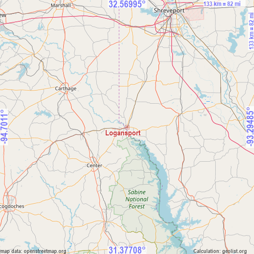
Logansport GPS coordinates[2]
31° 58' 31.62" North, 93° 59' 52.692" West
| Map corner | latitude | longitude |
|---|---|---|
| Upper-left | 32.56995°, | -94.7011° |
| Center: | 31.97545°, | -93.99797° |
| Lower-right: | 31.37708°, | -93.29485° |
| Map W x H: | 132.6×132.6 km | = 82.4×82.4mi |
| max Lat: | 71.29058° ⇑88.6% North |
| Logansport: | 31.97545° |
| min Lat: | ⇓11.4% South 19.06759° |
| min Long | Logansport | max Long |
| -171.73463° | -93.99797° | -66.98998° |
| W 31.4%⇐ | ⇒68.6% E |
Elevation
Elevation of Logansport is 71 m = 233 ft, and this is 223.8 m = 734 ft below average elevation for this country.
| Max E: |
3189 m = 10463 ft | 75.1% |
| Avg. | 294.8 m = 967 ft | |
| Logansport | 71 m = 233 ft | |
Min E: |
-60 m = -197 ft | 24.9% |
See also: United States elevation on elevation.city.
Geographical zone
Logansport is located in North temperate zone (between Tropic of Cancer and the Arctic Circle). Distance of this Northern Tropic circle is 949.4 km =589.9 mi to South.| Distance of | km | miles | from Logansport |
|---|---|---|---|
| North Pole | 6451.7 | 4008.9 | to North |
| Arctic Circle | 3845.8 | 2389.7 | to North |
| Tropic Cancer | 949.4 | 589.9 | to South |
| Equator | 3555.3 | 2209.2 | to South |


Nearby cities:
15 places around Logansport: (largest is in red/bold)
• Beckville
52.4 km =32.6 mi,  304°
304°
• Carthage
37.8 km =23.5 mi, 302°
• Center
26.3 km =16.3 mi,  220°
220°
• Garrison
49.5 km =30.8 mi,  250°
250°
• Greenwood
52 km =32.3 mi,  2°
2°
• Joaquin
5.5 km =3.4 mi,  258°
258°
• Mansfield
28.9 km =18 mi,  76°
76°
• Pleasant Hill
48.8 km =30.3 mi,  110°
110°
• San Augustine
50.6 km =31.4 mi,  191°
191°
• Stonewall
37.8 km =23.5 mi,  25°
25°
• Tatum
61.8 km =38.4 mi,  307°
307°
• Tenaha
23.5 km =14.6 mi, 261°
• Timpson
38.3 km =23.8 mi, 257°
• Waskom
56.3 km =35 mi,  354°
354°
• Zwolle
50.8 km =31.6 mi,  138°
138°
Sources, notices
• [Note1] Compared only with cities in United States existing in our database
• [Src1] Map data: © OpenStreetMap contributors (CC-BY-SA)
• [Src2] Other city data from geonames.org with taken over terms of usage.
• [Src3] Geographical zone / Annual Mean Temperature by Robert A. Rohde @ Wikipedia
