Mansfield geodata
Mansfield (Louisiana) is a seat of a second-order administrative division; located in United States in America/Chicago (GMT-5) time zone. With population of 4,946 people, there are 7237 cities with bigger population in this country. Compared to other cities in United States, 88.5% of cities are located further ↑North; 68% of cities are located further →East and 69.6% of cities have higher elevation than Mansfield. Note1


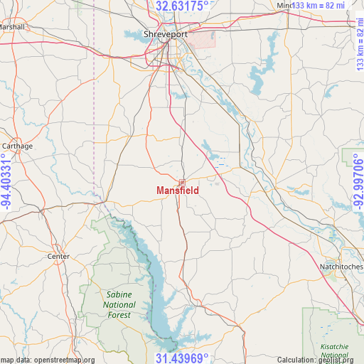
Mansfield GPS coordinates[2]
32° 2' 15.576" North, 93° 42' 0.648" West
| Map corner | latitude | longitude |
|---|---|---|
| Upper-left | 32.63175°, | -94.40331° |
| Center: | 32.03766°, | -93.70018° |
| Lower-right: | 31.43969°, | -92.99706° |
| Map W x H: | 132.5×132.5 km | = 82.3×82.3mi |
| max Lat: | 71.29058° ⇑88.5% North |
| Mansfield: | 32.03766° |
| min Lat: | ⇓11.5% South 19.06759° |
| min Long | Mansfield | max Long |
| -171.73463° | -93.70018° | -66.98998° |
| W 32%⇐ | ⇒68% E |
Elevation
Elevation of Mansfield is 103 m = 338 ft, and this is 191.8 m = 629 ft below average elevation for this country.
| Max E: |
3189 m = 10463 ft | 69.6% |
| Avg. | 294.8 m = 967 ft | |
| Mansfield | 103 m = 338 ft | |
Min E: |
-60 m = -197 ft | 30.4% |
See also: United States elevation on elevation.city.
Geographical zone
Mansfield is located in North temperate zone (between Tropic of Cancer and the Arctic Circle). Distance of this Northern Tropic circle is 956.3 km =594.2 mi to South.| Distance of | km | miles | from Mansfield |
|---|---|---|---|
| North Pole | 6444.8 | 4004.6 | to North |
| Arctic Circle | 3838.9 | 2385.4 | to North |
| Tropic Cancer | 956.3 | 594.2 | to South |
| Equator | 3562.3 | 2213.5 | to South |


Nearby cities:
15 places around Mansfield: (largest is in red/bold)
• Bossier City
53.3 km =33.1 mi,  356°
356°
• Center
52.6 km =32.7 mi,  239°
239°
• Coushatta
33.8 km =21 mi,  94°
94°
• Fort Jesup
54.9 km =34.1 mi,  149°
149°
• Greenwood
51.9 km =32.2 mi,  330°
330°
• Joaquin
34.4 km =21.4 mi,  256°
256°
• Lakeview
55.3 km =34.4 mi,  347°
347°
• Logansport
28.9 km =18 mi, 256°
• Martin
45.5 km =28.3 mi,  83°
83°
• Pleasant Hill
29.9 km =18.6 mi,  144°
144°
• Ringgold
51.1 km =31.8 mi,  50°
50°
• Shreveport
54.4 km =33.8 mi, 355°
• Stonewall
29.5 km =18.3 mi,  336°
336°
• Tenaha
52.3 km =32.5 mi, 258°
• Zwolle
45.5 km =28.3 mi,  173°
173°
Sources, notices
• [Note1] Compared only with cities in United States existing in our database
• [Src1] Map data: © OpenStreetMap contributors (CC-BY-SA)
• [Src2] Other city data from geonames.org with taken over terms of usage.
• [Src3] Geographical zone / Annual Mean Temperature by Robert A. Rohde @ Wikipedia
