Butner geodata
Butner (North Carolina) is a populated place; located in United States in America/New_York (GMT-4) time zone. With population of 7,751 people, there are 5402 cities with bigger population in this country. Compared to other cities in United States, 69.7% of cities are located further ↑North; 76.4% of cities are located further ←West and 67.9% of cities have higher elevation than Butner. Note1
Administrative division(s):
- Level 1: North Carolina
- Level 2: Granville County
- Level 3: Township of Dutchville


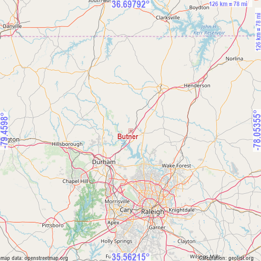
Butner GPS coordinates[2]
36° 7' 55.524" North, 78° 45' 24.012" West
| Map corner | latitude | longitude |
|---|---|---|
| Upper-left | 36.69792°, | -79.4598° |
| Center: | 36.13209°, | -78.75667° |
| Lower-right: | 35.56215°, | -78.05355° |
| Map W x H: | 126.3×126.3 km | = 78.5×78.5mi |
| max Lat: | 71.29058° ⇑69.7% North |
| Butner: | 36.13209° |
| min Lat: | ⇓30.3% South 19.06759° |
| min Long | Butner | max Long |
| -171.73463° | -78.75667° | -66.98998° |
| W 76.4%⇐ | ⇒23.6% E |
Elevation
Elevation of Butner is 113 m = 371 ft, and this is 181.8 m = 596 ft below average elevation for this country.
| Max E: |
3189 m = 10463 ft | 67.9% |
| Avg. | 294.8 m = 967 ft | |
| Butner | 113 m = 371 ft | |
Min E: |
-60 m = -197 ft | 32.1% |
See also: United States elevation on elevation.city.
Geographical zone
Butner is located in North temperate zone (between Tropic of Cancer and the Arctic Circle). Distance of this Northern Tropic circle is 1411.6 km =877.1 mi to South.| Distance of | km | miles | from Butner |
|---|---|---|---|
| North Pole | 5989.6 | 3721.8 | to North |
| Arctic Circle | 3383.7 | 2102.5 | to North |
| Tropic Cancer | 1411.6 | 877.1 | to South |
| Equator | 4017.5 | 2496.4 | to South |


Nearby cities:
15 places around Butner: (largest is in red/bold)
• Chapel Hill
36.3 km =22.6 mi,  227°
227°
• Creedmoor
6.4 km =4 mi,  99°
99°
• Durham
20 km =12.4 mi,  219°
219°
• Efland
37.5 km =23.3 mi,  261°
261°
• Franklinton
27 km =16.8 mi, 97°
• Gorman
12.2 km =7.6 mi,  209°
209°
• Hillsborough
31.5 km =19.6 mi, 258°
• Morrisville
34.9 km =21.7 mi,  190°
190°
• Oxford
24.8 km =15.4 mi,  36°
36°
• Rolesville
35.5 km =22.1 mi,  130°
130°
• Rougemont
18 km =11.2 mi,  302°
302°
• Roxboro
35.5 km =22.1 mi,  325°
325°
• South Henderson
37 km =23 mi,  58°
58°
• Wake Forest
27.9 km =17.3 mi, 127°
• Youngsville
28 km =17.4 mi,  115°
115°
Sources, notices
• [Note1] Compared only with cities in United States existing in our database
• [Src1] Map data: © OpenStreetMap contributors (CC-BY-SA)
• [Src2] Other city data from geonames.org with taken over terms of usage.
• [Src3] Geographical zone / Annual Mean Temperature by Robert A. Rohde @ Wikipedia
