Bokchito geodata
Bokchito (Oklahoma) is a populated place; located in United States in America/Chicago (GMT-5) time zone. With population of 657 people, there are 19109 cities with bigger population in this country. Compared to other cities in United States, 80.1% of cities are located further ↑North; 73.7% of cities are located further →East and 50.2% of cities have lower elevation than Bokchito. Note1


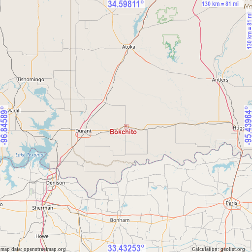
Bokchito GPS coordinates[2]
34° 1' 2.352" North, 96° 8' 33.936" West
| Map corner | latitude | longitude |
|---|---|---|
| Upper-left | 34.59811°, | -96.84589° |
| Center: | 34.01732°, | -96.14276° |
| Lower-right: | 33.43253°, | -95.43964° |
| Map W x H: | 129.6×129.6 km | = 80.5×80.5mi |
| max Lat: | 71.29058° ⇑80.1% North |
| Bokchito: | 34.01732° |
| min Lat: | ⇓19.9% South 19.06759° |
| min Long | Bokchito | max Long |
| -171.73463° | -96.14276° | -66.98998° |
| W 26.3%⇐ | ⇒73.7% E |
Elevation
Elevation of Bokchito is 199 m = 653 ft, and this is 95.8 m = 314 ft below average elevation for this country.
| Max E: |
3189 m = 10463 ft | 49.8% |
| Avg. | 294.8 m = 967 ft | |
| Bokchito | 199 m = 653 ft | |
Min E: |
-60 m = -197 ft | 50.2% |
See also: United States elevation on elevation.city.
Geographical zone
Bokchito is located in North temperate zone (between Tropic of Cancer and the Arctic Circle). Distance of this Northern Tropic circle is 1176.5 km =731 mi to South.| Distance of | km | miles | from Bokchito |
|---|---|---|---|
| North Pole | 6224.7 | 3867.8 | to North |
| Arctic Circle | 3618.8 | 2248.6 | to North |
| Tropic Cancer | 1176.5 | 731 | to South |
| Equator | 3782.4 | 2350.3 | to South |


Nearby cities:
15 places around Bokchito: (largest is in red/bold)
• Achille
30.4 km =18.9 mi,  227°
227°
• Atoka
41 km =25.5 mi,  1°
1°
• Bells
51.6 km =32.1 mi,  208°
208°
• Bonham
49 km =30.4 mi,  183°
183°
• Boswell
25.2 km =15.7 mi,  87°
87°
• Caddo
16.5 km =10.3 mi,  317°
317°
• Calera
27.9 km =17.3 mi,  250°
250°
• Cartwright
42.8 km =26.6 mi,  244°
244°
• Colbert
37.9 km =23.5 mi, 241°
• Denison
46.6 km =29 mi, 231°
• Durant
21.2 km =13.2 mi,  262°
262°
• Ector
50.4 km =31.3 mi,  193°
193°
• Honey Grove
52.8 km =32.8 mi,  155°
155°
• Preston
47.6 km =29.6 mi, 251°
• Savoy
50.9 km =31.6 mi,  203°
203°
Sources, notices
• [Note1] Compared only with cities in United States existing in our database
• [Src1] Map data: © OpenStreetMap contributors (CC-BY-SA)
• [Src2] Other city data from geonames.org with taken over terms of usage.
• [Src3] Geographical zone / Annual Mean Temperature by Robert A. Rohde @ Wikipedia
