Elgin geodata
Elgin (South Carolina) is a populated place; located in United States in America/New_York (GMT-4) time zone. With population of 1,475 people, there are 13774 cities with bigger population in this country. Compared to other cities in United States, 79.1% of cities are located further ↑North; 69.9% of cities are located further ←West and 66% of cities have higher elevation than Elgin. Note1


Elgin GPS coordinates[2]
34° 10' 15.528" North, 80° 47' 39.3" West
| Map corner | latitude | longitude |
|---|---|---|
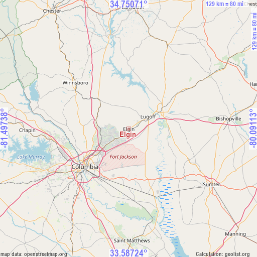
| Upper-left | 34.75071°, | -81.49738° |
| Center: | 34.17098°, | -80.79425° |
| Lower-right: | 33.58724°, | -80.09113° |
| Map W x H: | 129.4×129.4 km | = 80.4×80.4mi |
| max Lat: | 71.29058° ⇑79.1% North |
| Elgin: | 34.17098° |
| min Lat: | ⇓20.9% South 19.06759° |
| min Long | Elgin | max Long |
| -171.73463° | -80.79425° | -66.98998° |
| W 69.9%⇐ | ⇒30.1% E |
Elevation
Elevation of Elgin is 123 m = 404 ft, and this is 171.8 m = 564 ft below average elevation for this country.
| Max E: |
3189 m = 10463 ft | 66% |
| Avg. | 294.8 m = 967 ft | |
| Elgin | 123 m = 404 ft | |
Min E: |
-60 m = -197 ft | 34% |
See also: United States elevation on elevation.city.
Geographical zone
Elgin is located in North temperate zone (between Tropic of Cancer and the Arctic Circle). Distance of this Northern Tropic circle is 1193.5 km =741.6 mi to South.| Distance of | km | miles | from Elgin |
|---|---|---|---|
| North Pole | 6207.6 | 3857.2 | to North |
| Arctic Circle | 3601.7 | 2238 | to North |
| Tropic Cancer | 1193.5 | 741.6 | to South |
| Equator | 3799.5 | 2360.9 | to South |


Nearby cities:
15 places around Elgin: (largest is in red/bold)
• Arcadia Lakes
20.2 km =12.6 mi,  229°
229°
• Blythewood
17.2 km =10.7 mi,  286°
286°
• Camden
19.2 km =11.9 mi,  63°
63°
• Cayce
34.4 km =21.4 mi, 228°
• Columbia
29.1 km =18.1 mi, 229°
• Dentsville
19.2 km =11.9 mi, 231°
• Eastover
34 km =21.1 mi,  164°
164°
• Forest Acres
24.7 km =15.3 mi, 226°
• Hopkins
30.6 km =19 mi,  194°
194°
• Lugoff
11.5 km =7.1 mi, 57°
• Saint Andrews
33.9 km =21.1 mi,  245°
245°
• Stateburg
33.7 km =20.9 mi,  134°
134°
• West Columbia
32.5 km =20.2 mi, 232°
• Winnsboro Mills
34.1 km =21.2 mi,  308°
308°
• Woodfield
17.7 km =11 mi, 225°
Sources, notices
• [Note1] Compared only with cities in United States existing in our database
• [Src1] Map data: © OpenStreetMap contributors (CC-BY-SA)
• [Src2] Other city data from geonames.org with taken over terms of usage.
• [Src3] Geographical zone / Annual Mean Temperature by Robert A. Rohde @ Wikipedia
