Green Hill geodata
Green Hill (Tennessee) is a populated place; located in United States in America/Chicago (GMT-5) time zone. With population of 6,618 people, there are 6037 cities with bigger population in this country. Compared to other cities in United States, 69.3% of cities are located further ↑North; 51.4% of cities are located further ←West and 50.3% of cities have higher elevation than Green Hill. Note1


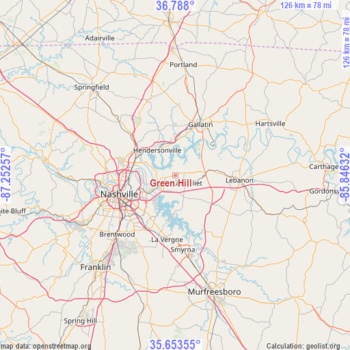
Green Hill GPS coordinates[2]
36° 13' 22.188" North, 86° 32' 57.984" West
| Map corner | latitude | longitude |
|---|---|---|
| Upper-left | 36.788°, | -87.25257° |
| Center: | 36.22283°, | -86.54944° |
| Lower-right: | 35.65355°, | -85.84632° |
| Map W x H: | 126.1×126.1 km | = 78.4×78.4mi |
| max Lat: | 71.29058° ⇑69.3% North |
| Green Hill: | 36.22283° |
| min Lat: | ⇓30.7% South 19.06759° |
| min Long | Green Hill | max Long |
| -171.73463° | -86.54944° | -66.98998° |
| W 51.4%⇐ | ⇒48.6% E |
Elevation
Elevation of Green Hill is 197 m = 646 ft, and this is 97.8 m = 321 ft below average elevation for this country.
| Max E: |
3189 m = 10463 ft | 50.3% |
| Avg. | 294.8 m = 967 ft | |
| Green Hill | 197 m = 646 ft | |
Min E: |
-60 m = -197 ft | 49.7% |
See also: United States elevation on elevation.city.
Geographical zone
Green Hill is located in North temperate zone (between Tropic of Cancer and the Arctic Circle). Distance of this Northern Tropic circle is 1421.7 km =883.4 mi to South.| Distance of | km | miles | from Green Hill |
|---|---|---|---|
| North Pole | 5979.5 | 3715.5 | to North |
| Arctic Circle | 3373.6 | 2096.3 | to North |
| Tropic Cancer | 1421.7 | 883.4 | to South |
| Equator | 4027.6 | 2502.6 | to South |


Nearby cities:
15 places around Green Hill: (largest is in red/bold)
• Berry Hill
22.8 km =14.2 mi,  238°
238°
• Gallatin
20.6 km =12.8 mi,  26°
26°
• Goodlettsville
18.4 km =11.4 mi,  307°
307°
• Hendersonville
11.1 km =6.9 mi,  325°
325°
• La Vergne
23.2 km =14.4 mi,  187°
187°
• Lakewood
8 km =5 mi,  286°
286°
• Lebanon
23.2 km =14.4 mi,  94°
94°
• Millersville
21.9 km =13.6 mi,  318°
318°
• Mount Juliet
3.8 km =2.4 mi,  132°
132°
• Nashville
22 km =13.7 mi,  253°
253°
• Oak Hill
25.8 km =16 mi,  234°
234°
• Ridgetop
28.1 km =17.5 mi, 312°
• Rural Hill
13.4 km =8.3 mi,  151°
151°
• Shackle Island
17.5 km =10.9 mi,  339°
339°
• Smyrna
26.8 km =16.7 mi,  174°
174°
Sources, notices
• [Note1] Compared only with cities in United States existing in our database
• [Src1] Map data: © OpenStreetMap contributors (CC-BY-SA)
• [Src2] Other city data from geonames.org with taken over terms of usage.
• [Src3] Geographical zone / Annual Mean Temperature by Robert A. Rohde @ Wikipedia
