Pigeon Forge geodata
Pigeon Forge (Tennessee) is a populated place; located in United States in America/New_York (GMT-4) time zone. With population of 6,171 people, there are 6291 cities with bigger population in this country. Compared to other cities in United States, 71.4% of cities are located further ↑North; 60.5% of cities are located further ←West and 74.4% of cities have lower elevation than Pigeon Forge. Note1


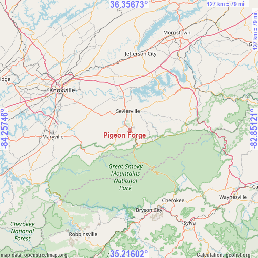
Pigeon Forge GPS coordinates[2]
35° 47' 18.312" North, 83° 33' 15.588" West
| Map corner | latitude | longitude |
|---|---|---|
| Upper-left | 36.35673°, | -84.25746° |
| Center: | 35.78842°, | -83.55433° |
| Lower-right: | 35.21602°, | -82.85121° |
| Map W x H: | 126.8×126.8 km | = 78.8×78.8mi |
| max Lat: | 71.29058° ⇑71.4% North |
| Pigeon Forge: | 35.78842° |
| min Lat: | ⇓28.6% South 19.06759° |
| min Long | Pigeon Forge | max Long |
| -171.73463° | -83.55433° | -66.98998° |
| W 60.5%⇐ | ⇒39.5% E |
Elevation
Elevation of Pigeon Forge is 309 m = 1014 ft, and this is 14.2 m = 47 ft above average elevation for this country.
| Max E: |
3189 m = 10463 ft | 25.6% |
| Pigeon Forge | 309 m 1014 ft | |
| Avg. | 294.8 m = 967 ft | |
Min E: |
-60 m = -197 ft | 74.4% |
See also: United States elevation on elevation.city.
Geographical zone
Pigeon Forge is located in North temperate zone (between Tropic of Cancer and the Arctic Circle). Distance of this Northern Tropic circle is 1373.4 km =853.4 mi to South.| Distance of | km | miles | from Pigeon Forge |
|---|---|---|---|
| North Pole | 6027.8 | 3745.5 | to North |
| Arctic Circle | 3421.9 | 2126.3 | to North |
| Tropic Cancer | 1373.4 | 853.4 | to South |
| Equator | 3979.3 | 2472.6 | to South |


Nearby cities:
15 places around Pigeon Forge: (largest is in red/bold)
• Alcoa
37.8 km =23.5 mi,  270°
270°
• Dandridge
28.2 km =17.5 mi,  26°
26°
• Eagleton Village
34.1 km =21.2 mi, 271°
• Fair Garden
18 km =11.2 mi,  45°
45°
• Gatlinburg
9.1 km =5.7 mi,  155°
155°
• Jefferson City
37.5 km =23.3 mi,  8°
8°
• Knoxville
38.2 km =23.7 mi,  300°
300°
• Maryville
37.7 km =23.4 mi,  264°
264°
• Mascot
34.9 km =21.7 mi,  330°
330°
• New Market
35.1 km =21.8 mi,  0°
0°
• Pittman Center
14.6 km =9.1 mi,  102°
102°
• Rockford
35.1 km =21.8 mi,  277°
277°
• Sevierville
8.9 km =5.5 mi,  355°
355°
• Seymour
19.1 km =11.9 mi,  306°
306°
• Wildwood
28.6 km =17.8 mi, 273°
Sources, notices
• [Note1] Compared only with cities in United States existing in our database
• [Src1] Map data: © OpenStreetMap contributors (CC-BY-SA)
• [Src2] Other city data from geonames.org with taken over terms of usage.
• [Src3] Geographical zone / Annual Mean Temperature by Robert A. Rohde @ Wikipedia
