Lebanon geodata
Lebanon (Tennessee) is a seat of a second-order administrative division; located in United States in America/Chicago (GMT-5) time zone. With population of 30,262 people, there are 1653 cities with bigger population in this country. Compared to other cities in United States, 69.4% of cities are located further ↑North; 52.1% of cities are located further ←West and 58.8% of cities have higher elevation than Lebanon. Note1


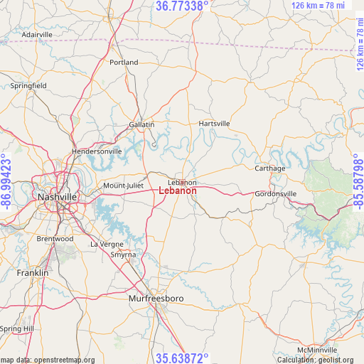
Lebanon GPS coordinates[2]
36° 12' 29.196" North, 86° 17' 27.96" West
| Map corner | latitude | longitude |
|---|---|---|
| Upper-left | 36.77338°, | -86.99423° |
| Center: | 36.20811°, | -86.2911° |
| Lower-right: | 35.63872°, | -85.58798° |
| Map W x H: | 126.2×126.2 km | = 78.4×78.4mi |
| max Lat: | 71.29058° ⇑69.4% North |
| Lebanon: | 36.20811° |
| min Lat: | ⇓30.6% South 19.06759° |
| min Long | Lebanon | max Long |
| -171.73463° | -86.2911° | -66.98998° |
| W 52.1%⇐ | ⇒47.9% E |
Elevation
Elevation of Lebanon is 161 m = 528 ft, and this is 133.8 m = 439 ft below average elevation for this country.
| Max E: |
3189 m = 10463 ft | 58.8% |
| Avg. | 294.8 m = 967 ft | |
| Lebanon | 161 m = 528 ft | |
Min E: |
-60 m = -197 ft | 41.2% |
See also: United States elevation on elevation.city.
Geographical zone
Lebanon is located in North temperate zone (between Tropic of Cancer and the Arctic Circle). Distance of this Northern Tropic circle is 1420 km =882.3 mi to South.| Distance of | km | miles | from Lebanon |
|---|---|---|---|
| North Pole | 5981.1 | 3716.5 | to North |
| Arctic Circle | 3375.2 | 2097.3 | to North |
| Tropic Cancer | 1420 | 882.3 | to South |
| Equator | 4026 | 2501.6 | to South |


Nearby cities:
15 places around Lebanon: (largest is in red/bold)
• Alexandria
27.3 km =17 mi,  122°
122°
• Carthage
30.8 km =19.1 mi,  80°
80°
• Castalian Springs
20.7 km =12.9 mi,  355°
355°
• Gallatin
24.4 km =15.2 mi,  325°
325°
• Gordonsville
32.7 km =20.3 mi,  96°
96°
• Green Hill
23.2 km =14.4 mi,  274°
274°
• Hartsville
23.2 km =14.4 mi,  28°
28°
• Hendersonville
31.4 km =19.5 mi,  290°
290°
• La Vergne
33.8 km =21 mi,  230°
230°
• Lakewood
31.1 km =19.3 mi,  277°
277°
• Mount Juliet
20.4 km =12.7 mi, 267°
• Rural Hill
19.7 km =12.2 mi,  238°
238°
• Smyrna
32.3 km =20.1 mi,  219°
219°
• South Carthage
30.7 km =19.1 mi, 82°
• Watertown
18.6 km =11.6 mi,  129°
129°
Sources, notices
• [Note1] Compared only with cities in United States existing in our database
• [Src1] Map data: © OpenStreetMap contributors (CC-BY-SA)
• [Src2] Other city data from geonames.org with taken over terms of usage.
• [Src3] Geographical zone / Annual Mean Temperature by Robert A. Rohde @ Wikipedia
