Brenham geodata
Brenham (Texas) is a seat of a second-order administrative division; located in United States in America/Chicago (GMT-5) time zone. With population of 16,579 people, there are 2964 cities with bigger population in this country. Compared to other cities in United States, 92.9% of cities are located further ↑North; 74.2% of cities are located further →East and 68.6% of cities have higher elevation than Brenham. Note1


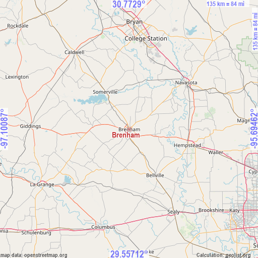
Brenham GPS coordinates[2]
30° 10' 0.768" North, 96° 23' 51.864" West
| Map corner | latitude | longitude |
|---|---|---|
| Upper-left | 30.7729°, | -97.10087° |
| Center: | 30.16688°, | -96.39774° |
| Lower-right: | 29.55712°, | -95.69462° |
| Map W x H: | 135.2×135.2 km | = 84×84mi |
| max Lat: | 71.29058° ⇑92.9% North |
| Brenham: | 30.16688° |
| min Lat: | ⇓7.1% South 19.06759° |
| min Long | Brenham | max Long |
| -171.73463° | -96.39774° | -66.98998° |
| W 25.8%⇐ | ⇒74.2% E |
Elevation
Elevation of Brenham is 109 m = 358 ft, and this is 185.8 m = 610 ft below average elevation for this country.
| Max E: |
3189 m = 10463 ft | 68.6% |
| Avg. | 294.8 m = 967 ft | |
| Brenham | 109 m = 358 ft | |
Min E: |
-60 m = -197 ft | 31.4% |
See also: United States elevation on elevation.city.
Geographical zone
Brenham is located in North temperate zone (between Tropic of Cancer and the Arctic Circle). Distance of this Northern Tropic circle is 748.3 km =465 mi to South.| Distance of | km | miles | from Brenham |
|---|---|---|---|
| North Pole | 6652.8 | 4133.9 | to North |
| Arctic Circle | 4046.9 | 2514.6 | to North |
| Tropic Cancer | 748.3 | 465 | to South |
| Equator | 3354.2 | 2084.2 | to South |


Nearby cities:
15 places around Brenham: (largest is in red/bold)
• Anderson
53.1 km =33 mi,  47°
47°
• Bellville
27.6 km =17.1 mi,  150°
150°
• Caldwell
49.4 km =30.7 mi,  325°
325°
• College Station
51.6 km =32.1 mi,  6°
6°
• Columbus
53 km =32.9 mi,  194°
194°
• Giddings
51.8 km =32.2 mi,  271°
271°
• Hempstead
31.7 km =19.7 mi,  104°
104°
• Navasota
38.6 km =24 mi, 50°
• Pine Island
36.7 km =22.8 mi,  109°
109°
• Prairie View
40.3 km =25 mi, 101°
• San Felipe
50.5 km =31.4 mi, 145°
• Sealy
48.8 km =30.3 mi, 151°
• Snook
36.4 km =22.6 mi,  349°
349°
• Somerville
23.5 km =14.6 mi, 327°
• Waller
46.9 km =29.1 mi, 105°
Sources, notices
• [Note1] Compared only with cities in United States existing in our database
• [Src1] Map data: © OpenStreetMap contributors (CC-BY-SA)
• [Src2] Other city data from geonames.org with taken over terms of usage.
• [Src3] Geographical zone / Annual Mean Temperature by Robert A. Rohde @ Wikipedia
