Giddings geodata
Giddings (Texas) is a seat of a second-order administrative division; located in United States in America/Chicago (GMT-5) time zone. With population of 5,064 people, there are 7115 cities with bigger population in this country. Compared to other cities in United States, 92.8% of cities are located further ↑North; 75.5% of cities are located further →East and 59.5% of cities have higher elevation than Giddings. Note1


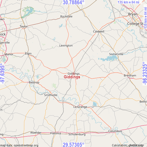
Giddings GPS coordinates[2]
30° 10' 57.792" North, 96° 56' 10.932" West
| Map corner | latitude | longitude |
|---|---|---|
| Upper-left | 30.78864°, | -97.6395° |
| Center: | 30.18272°, | -96.93637° |
| Lower-right: | 29.57305°, | -96.23325° |
| Map W x H: | 135.2×135.2 km | = 84×84mi |
| max Lat: | 71.29058° ⇑92.8% North |
| Giddings: | 30.18272° |
| min Lat: | ⇓7.2% South 19.06759° |
| min Long | Giddings | max Long |
| -171.73463° | -96.93637° | -66.98998° |
| W 24.5%⇐ | ⇒75.5% E |
Elevation
Elevation of Giddings is 157 m = 515 ft, and this is 137.8 m = 452 ft below average elevation for this country.
| Max E: |
3189 m = 10463 ft | 59.5% |
| Avg. | 294.8 m = 967 ft | |
| Giddings | 157 m = 515 ft | |
Min E: |
-60 m = -197 ft | 40.5% |
See also: United States elevation on elevation.city.
Geographical zone
Giddings is located in North temperate zone (between Tropic of Cancer and the Arctic Circle). Distance of this Northern Tropic circle is 750.1 km =466.1 mi to South.| Distance of | km | miles | from Giddings |
|---|---|---|---|
| North Pole | 6651.1 | 4132.8 | to North |
| Arctic Circle | 4045.2 | 2513.6 | to North |
| Tropic Cancer | 750.1 | 466.1 | to South |
| Equator | 3356 | 2085.3 | to South |


Nearby cities:
15 places around Giddings: (largest is in red/bold)
• Bastrop
37.3 km =23.2 mi,  257°
257°
• Brenham
51.8 km =32.2 mi,  91°
91°
• Caldwell
45.2 km =28.1 mi,  31°
31°
• Camp Swift
34.2 km =21.3 mi,  271°
271°
• Circle D-KC Estates
28.8 km =17.9 mi, 265°
• Elgin
45.6 km =28.3 mi,  294°
294°
• La Grange
31.4 km =19.5 mi,  169°
169°
• Lexington
27.3 km =17 mi,  344°
344°
• McDade
31.1 km =19.3 mi, 291°
• Rockdale
52.9 km =32.9 mi,  353°
353°
• Smithville
28.9 km =18 mi,  227°
227°
• Somerville
43.2 km =26.8 mi,  65°
65°
• Thorndale
54.4 km =33.8 mi,  331°
331°
• Weimar
55.4 km =34.4 mi,  164°
164°
• Wyldwood
51.9 km =32.2 mi, 263°
Sources, notices
• [Note1] Compared only with cities in United States existing in our database
• [Src1] Map data: © OpenStreetMap contributors (CC-BY-SA)
• [Src2] Other city data from geonames.org with taken over terms of usage.
• [Src3] Geographical zone / Annual Mean Temperature by Robert A. Rohde @ Wikipedia
