Farmers Branch geodata
Farmers Branch (Texas) is a populated place; located in United States in America/Chicago (GMT-5) time zone. With population of 32,689 people, there are 1523 cities with bigger population in this country. Compared to other cities in United States, 85.4% of cities are located further ↑North; 75.4% of cities are located further →East and 61.5% of cities have higher elevation than Farmers Branch. Note1


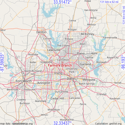
Farmers Branch GPS coordinates[2]
32° 55' 35.436" North, 96° 53' 46.032" West
| Map corner | latitude | longitude |
|---|---|---|
| Upper-left | 33.51472°, | -97.59925° |
| Center: | 32.92651°, | -96.89612° |
| Lower-right: | 32.33437°, | -96.193° |
| Map W x H: | 131.2×131.2 km | = 81.5×81.5mi |
| max Lat: | 71.29058° ⇑85.4% North |
| Farmers Branch: | 32.92651° |
| min Lat: | ⇓14.6% South 19.06759° |
| min Long | Farmers Branch | max Long |
| -171.73463° | -96.89612° | -66.98998° |
| W 24.6%⇐ | ⇒75.4% E |
Elevation
Elevation of Farmers Branch is 147 m = 482 ft, and this is 147.8 m = 485 ft below average elevation for this country.
| Max E: |
3189 m = 10463 ft | 61.5% |
| Avg. | 294.8 m = 967 ft | |
| Farmers Branch | 147 m = 482 ft | |
Min E: |
-60 m = -197 ft | 38.5% |
See also: United States elevation on elevation.city.
Geographical zone
Farmers Branch is located in North temperate zone (between Tropic of Cancer and the Arctic Circle). Distance of this Northern Tropic circle is 1055.2 km =655.7 mi to South.| Distance of | km | miles | from Farmers Branch |
|---|---|---|---|
| North Pole | 6346 | 3943.2 | to North |
| Arctic Circle | 3740.1 | 2324 | to North |
| Tropic Cancer | 1055.2 | 655.7 | to South |
| Equator | 3661.1 | 2274.9 | to South |


Nearby cities:
15 places around Farmers Branch: (largest is in red/bold)
• Addison
7.4 km =4.6 mi,  57°
57°
• Carrollton
3.1 km =1.9 mi,  10°
10°
• Cockrell Hill
21.2 km =13.2 mi,  177°
177°
• Coppell
11.5 km =7.1 mi,  285°
285°
• Dallas
18 km =11.2 mi,  152°
152°
• Euless
20 km =12.4 mi,  240°
240°
• Flower Mound
21.1 km =13.1 mi,  297°
297°
• Grapevine
17 km =10.6 mi,  272°
272°
• Highland Park
14.2 km =8.8 mi,  136°
136°
• Irving
13.4 km =8.3 mi,  201°
201°
• Lewisville
16.2 km =10.1 mi,  325°
325°
• Plano
21.1 km =13.1 mi, 60°
• Richardson
15.7 km =9.8 mi,  81°
81°
• The Colony
18.1 km =11.2 mi,  2°
2°
• University Park
12.3 km =7.6 mi,  133°
133°
Sources, notices
• [Note1] Compared only with cities in United States existing in our database
• [Src1] Map data: © OpenStreetMap contributors (CC-BY-SA)
• [Src2] Other city data from geonames.org with taken over terms of usage.
• [Src3] Geographical zone / Annual Mean Temperature by Robert A. Rohde @ Wikipedia
