Beckville geodata
Beckville (Texas) is a populated place; located in United States in America/Chicago (GMT-5) time zone. With population of 843 people, there are 17421 cities with bigger population in this country. Compared to other cities in United States, 88% of cities are located further ↑North; 69.8% of cities are located further →East and 69.1% of cities have higher elevation than Beckville. Note1


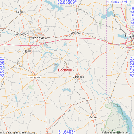
Beckville GPS coordinates[2]
32° 14' 34.584" North, 94° 27' 19.728" West
| Map corner | latitude | longitude |
|---|---|---|
| Upper-left | 32.83569°, | -95.15861° |
| Center: | 32.24294°, | -94.45548° |
| Lower-right: | 31.6463°, | -93.75236° |
| Map W x H: | 132.2×132.2 km | = 82.1×82.1mi |
| max Lat: | 71.29058° ⇑88% North |
| Beckville: | 32.24294° |
| min Lat: | ⇓12% South 19.06759° |
| min Long | Beckville | max Long |
| -171.73463° | -94.45548° | -66.98998° |
| W 30.2%⇐ | ⇒69.8% E |
Elevation
Elevation of Beckville is 106 m = 348 ft, and this is 188.8 m = 619 ft below average elevation for this country.
| Max E: |
3189 m = 10463 ft | 69.1% |
| Avg. | 294.8 m = 967 ft | |
| Beckville | 106 m = 348 ft | |
Min E: |
-60 m = -197 ft | 30.9% |
See also: United States elevation on elevation.city.
Geographical zone
Beckville is located in North temperate zone (between Tropic of Cancer and the Arctic Circle). Distance of this Northern Tropic circle is 979.2 km =608.4 mi to South.| Distance of | km | miles | from Beckville |
|---|---|---|---|
| North Pole | 6422 | 3990.4 | to North |
| Arctic Circle | 3816.1 | 2371.2 | to North |
| Tropic Cancer | 979.2 | 608.4 | to South |
| Equator | 3585.1 | 2227.7 | to South |


Nearby cities:
15 places around Beckville: (largest is in red/bold)
• Carthage
14.6 km =9.1 mi,  130°
130°
• Easton
20 km =12.4 mi,  323°
323°
• Garrison
46.7 km =29 mi,  184°
184°
• Hallsville
31.1 km =19.3 mi,  339°
339°
• Henderson
33.9 km =21.1 mi,  252°
252°
• Joaquin
48.7 km =30.3 mi, 129°
• Kilgore
42.6 km =26.5 mi,  291°
291°
• Lakeport
29.9 km =18.6 mi,  308°
308°
• Longview
39.2 km =24.4 mi, 316°
• Marshall
34.6 km =21.5 mi,  13°
13°
• New London
45.6 km =28.3 mi,  269°
269°
• Tatum
9.9 km =6.2 mi, 324°
• Tenaha
38.8 km =24.1 mi,  149°
149°
• Timpson
38.1 km =23.7 mi,  171°
171°
• Waskom
45.5 km =28.3 mi,  54°
54°
Sources, notices
• [Note1] Compared only with cities in United States existing in our database
• [Src1] Map data: © OpenStreetMap contributors (CC-BY-SA)
• [Src2] Other city data from geonames.org with taken over terms of usage.
• [Src3] Geographical zone / Annual Mean Temperature by Robert A. Rohde @ Wikipedia
