Rio Vista geodata
Rio Vista (Texas) is a populated place; located in United States in America/Chicago (GMT-5) time zone. With population of 933 people, there are 16768 cities with bigger population in this country. Compared to other cities in United States, 88% of cities are located further ↑North; 76.8% of cities are located further →East and 57.2% of cities have lower elevation than Rio Vista. Note1


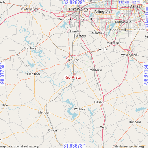
Rio Vista GPS coordinates[2]
32° 14' 0.528" North, 97° 22' 28.056" West
| Map corner | latitude | longitude |
|---|---|---|
| Upper-left | 32.82629°, | -98.07759° |
| Center: | 32.23348°, | -97.37446° |
| Lower-right: | 31.63678°, | -96.67134° |
| Map W x H: | 132.3×132.3 km | = 82.2×82.2mi |
| max Lat: | 71.29058° ⇑88% North |
| Rio Vista: | 32.23348° |
| min Lat: | ⇓12% South 19.06759° |
| min Long | Rio Vista | max Long |
| -171.73463° | -97.37446° | -66.98998° |
| W 23.2%⇐ | ⇒76.8% E |
Elevation
Elevation of Rio Vista is 227 m = 745 ft, and this is 67.8 m = 222 ft below average elevation for this country.
| Max E: |
3189 m = 10463 ft | 42.8% |
| Avg. | 294.8 m = 967 ft | |
| Rio Vista | 227 m = 745 ft | |
Min E: |
-60 m = -197 ft | 57.2% |
See also: United States elevation on elevation.city.
Geographical zone
Rio Vista is located in North temperate zone (between Tropic of Cancer and the Arctic Circle). Distance of this Northern Tropic circle is 978.1 km =607.8 mi to South.| Distance of | km | miles | from Rio Vista |
|---|---|---|---|
| North Pole | 6423 | 3991.1 | to North |
| Arctic Circle | 3817.1 | 2371.8 | to North |
| Tropic Cancer | 978.1 | 607.8 | to South |
| Equator | 3584 | 2227 | to South |


Nearby cities:
15 places around Rio Vista: (largest is in red/bold)
• Alvarado
24.6 km =15.3 mi,  38°
38°
• Burleson
34.7 km =21.6 mi,  8°
8°
• Cleburne
12.7 km =7.9 mi,  354°
354°
• Glen Rose
35.8 km =22.2 mi,  270°
270°
• Godley
27.9 km =17.3 mi,  329°
329°
• Grandview
18.8 km =11.7 mi,  77°
77°
• Hillsboro
33.8 km =21 mi,  137°
137°
• Itasca
22.7 km =14.1 mi,  111°
111°
• Joshua
25.4 km =15.8 mi,  357°
357°
• Keene
18.8 km =11.7 mi, 14°
• Maypearl
35.2 km =21.9 mi, 75°
• Pecan Plantation
31.6 km =19.6 mi,  296°
296°
• Plum Grove
36.5 km =22.7 mi,  96°
96°
• Venus
33.9 km =21.1 mi,  48°
48°
• Whitney
31.7 km =19.7 mi,  170°
170°
Sources, notices
• [Note1] Compared only with cities in United States existing in our database
• [Src1] Map data: © OpenStreetMap contributors (CC-BY-SA)
• [Src2] Other city data from geonames.org with taken over terms of usage.
• [Src3] Geographical zone / Annual Mean Temperature by Robert A. Rohde @ Wikipedia
