Newton geodata
Newton (Texas) is a seat of a second-order administrative division; located in United States in America/Chicago (GMT-5) time zone. With population of 2,403 people, there are 10841 cities with bigger population in this country. Compared to other cities in United States, 91% of cities are located further ↑North; 68.1% of cities are located further →East and 76.7% of cities have higher elevation than Newton. Note1


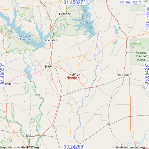
Newton GPS coordinates[2]
30° 50' 54.708" North, 93° 45' 26.64" West
| Map corner | latitude | longitude |
|---|---|---|
| Upper-left | 31.45027°, | -94.46053° |
| Center: | 30.84853°, | -93.7574° |
| Lower-right: | 30.24299°, | -93.05428° |
| Map W x H: | 134.2×134.2 km | = 83.4×83.4mi |
| max Lat: | 71.29058° ⇑91% North |
| Newton: | 30.84853° |
| min Lat: | ⇓9% South 19.06759° |
| min Long | Newton | max Long |
| -171.73463° | -93.7574° | -66.98998° |
| W 31.9%⇐ | ⇒68.1% E |
Elevation
Elevation of Newton is 62 m = 203 ft, and this is 232.8 m = 764 ft below average elevation for this country.
| Max E: |
3189 m = 10463 ft | 76.7% |
| Avg. | 294.8 m = 967 ft | |
| Newton | 62 m = 203 ft | |
Min E: |
-60 m = -197 ft | 23.3% |
See also: United States elevation on elevation.city.
Geographical zone
Newton is located in North temperate zone (between Tropic of Cancer and the Arctic Circle). Distance of this Northern Tropic circle is 824.1 km =512.1 mi to South.| Distance of | km | miles | from Newton |
|---|---|---|---|
| North Pole | 6577 | 4086.8 | to North |
| Arctic Circle | 3971.1 | 2467.5 | to North |
| Tropic Cancer | 824.1 | 512.1 | to South |
| Equator | 3430 | 2131.3 | to South |


Nearby cities:
15 places around Newton: (largest is in red/bold)
• Buna
50.2 km =31.2 mi,  202°
202°
• DeQuincy
54 km =33.6 mi,  144°
144°
• DeRidder
44.7 km =27.8 mi,  90°
90°
• Fort Polk South
56.3 km =35 mi,  66°
66°
• Hemphill
55.4 km =34.4 mi,  351°
351°
• Jasper
24.2 km =15 mi,  289°
289°
• Kirbyville
24.6 km =15.3 mi,  211°
211°
• Leesville
57.6 km =35.8 mi,  55°
55°
• Longville
57.1 km =35.5 mi,  118°
118°
• Merryville
23.2 km =14.4 mi, 116°
• New Llano
55 km =34.2 mi, 57°
• Pineland
49 km =30.4 mi,  335°
335°
• Rosepine
46 km =28.6 mi,  80°
80°
• Sam Rayburn
35.8 km =22.2 mi,  312°
312°
• South Toledo Bend
36.9 km =22.9 mi,  23°
23°
Sources, notices
• [Note1] Compared only with cities in United States existing in our database
• [Src1] Map data: © OpenStreetMap contributors (CC-BY-SA)
• [Src2] Other city data from geonames.org with taken over terms of usage.
• [Src3] Geographical zone / Annual Mean Temperature by Robert A. Rohde @ Wikipedia
