Jasper geodata
Jasper (Texas) is a seat of a second-order administrative division; located in United States in America/Chicago (GMT-5) time zone. With population of 7,619 people, there are 5467 cities with bigger population in this country. Compared to other cities in United States, 90.9% of cities are located further ↑North; 68.6% of cities are located further →East and 76.2% of cities have higher elevation than Jasper. Note1


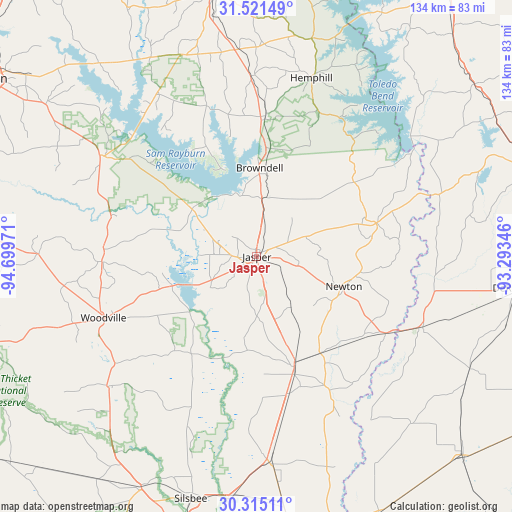
Jasper GPS coordinates[2]
30° 55' 12.72" North, 93° 59' 47.688" West
| Map corner | latitude | longitude |
|---|---|---|
| Upper-left | 31.52149°, | -94.69971° |
| Center: | 30.9202°, | -93.99658° |
| Lower-right: | 30.31511°, | -93.29346° |
| Map W x H: | 134.1×134.1 km | = 83.3×83.3mi |
| max Lat: | 71.29058° ⇑90.9% North |
| Jasper: | 30.9202° |
| min Lat: | ⇓9.1% South 19.06759° |
| min Long | Jasper | max Long |
| -171.73463° | -93.99658° | -66.98998° |
| W 31.4%⇐ | ⇒68.6% E |
Elevation
Elevation of Jasper is 65 m = 213 ft, and this is 229.8 m = 754 ft below average elevation for this country.
| Max E: |
3189 m = 10463 ft | 76.2% |
| Avg. | 294.8 m = 967 ft | |
| Jasper | 65 m = 213 ft | |
Min E: |
-60 m = -197 ft | 23.8% |
See also: United States elevation on elevation.city.
Geographical zone
Jasper is located in North temperate zone (between Tropic of Cancer and the Arctic Circle). Distance of this Northern Tropic circle is 832.1 km =517 mi to South.| Distance of | km | miles | from Jasper |
|---|---|---|---|
| North Pole | 6569.1 | 4081.8 | to North |
| Arctic Circle | 3963.2 | 2462.6 | to North |
| Tropic Cancer | 832.1 | 517 | to South |
| Equator | 3438 | 2136.3 | to South |


Nearby cities:
15 places around Jasper: (largest is in red/bold)
• Buna
54.3 km =33.7 mi,  176°
176°
• Colmesneil
40.6 km =25.2 mi,  268°
268°
• Evadale
63.3 km =39.3 mi,  186°
186°
• Hemphill
48.9 km =30.4 mi,  16°
16°
• Kirbyville
30.5 km =19 mi,  161°
161°
• Merryville
47.3 km =29.4 mi,  112°
112°
• Milam
58.7 km =36.5 mi,  14°
14°
• Newton
24.2 km =15 mi, 109°
• Pineland
36.5 km =22.7 mi,  3°
3°
• Sam Rayburn
16.4 km =10.2 mi,  346°
346°
• South Toledo Bend
45.5 km =28.3 mi,  55°
55°
• Warren
52 km =32.3 mi,  229°
229°
• Wildwood
61.2 km =38 mi,  224°
224°
• Woodville
43.1 km =26.8 mi,  248°
248°
• Zavalla
48.8 km =30.3 mi,  302°
302°
Sources, notices
• [Note1] Compared only with cities in United States existing in our database
• [Src1] Map data: © OpenStreetMap contributors (CC-BY-SA)
• [Src2] Other city data from geonames.org with taken over terms of usage.
• [Src3] Geographical zone / Annual Mean Temperature by Robert A. Rohde @ Wikipedia
