Hemphill geodata
Hemphill (Texas) is a seat of a second-order administrative division; located in United States in America/Chicago (GMT-5) time zone. With population of 1,218 people, there are 15026 cities with bigger population in this country. Compared to other cities in United States, 90% of cities are located further ↑North; 68.3% of cities are located further →East and 71.3% of cities have higher elevation than Hemphill. Note1


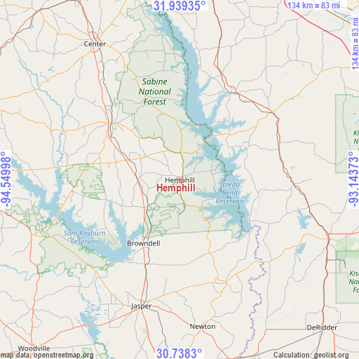
Hemphill GPS coordinates[2]
31° 20' 26.664" North, 93° 50' 48.66" West
| Map corner | latitude | longitude |
|---|---|---|
| Upper-left | 31.93935°, | -94.54998° |
| Center: | 31.34074°, | -93.84685° |
| Lower-right: | 30.7383°, | -93.14373° |
| Map W x H: | 133.5×133.5 km | = 83×83mi |
| max Lat: | 71.29058° ⇑90% North |
| Hemphill: | 31.34074° |
| min Lat: | ⇓10% South 19.06759° |
| min Long | Hemphill | max Long |
| -171.73463° | -93.84685° | -66.98998° |
| W 31.7%⇐ | ⇒68.3% E |
Elevation
Elevation of Hemphill is 93 m = 305 ft, and this is 201.8 m = 662 ft below average elevation for this country.
| Max E: |
3189 m = 10463 ft | 71.3% |
| Avg. | 294.8 m = 967 ft | |
| Hemphill | 93 m = 305 ft | |
Min E: |
-60 m = -197 ft | 28.7% |
See also: United States elevation on elevation.city.
Geographical zone
Hemphill is located in North temperate zone (between Tropic of Cancer and the Arctic Circle). Distance of this Northern Tropic circle is 878.8 km =546.1 mi to South.| Distance of | km | miles | from Hemphill |
|---|---|---|---|
| North Pole | 6522.3 | 4052.8 | to North |
| Arctic Circle | 3916.4 | 2433.5 | to North |
| Tropic Cancer | 878.8 | 546.1 | to South |
| Equator | 3484.8 | 2165.4 | to South |


Nearby cities:
15 places around Hemphill: (largest is in red/bold)
• Anacoco
49 km =30.4 mi,  101°
101°
• Center
59.6 km =37 mi,  328°
328°
• Florien
38.7 km =24 mi,  72°
72°
• Fort Jesup
51.8 km =32.2 mi,  54°
54°
• Jasper
48.9 km =30.4 mi,  196°
196°
• Leesville
59.9 km =37.2 mi,  111°
111°
• Many
42.7 km =26.5 mi, 53°
• Milam
10.2 km =6.3 mi,  0°
0°
• Newton
55.4 km =34.4 mi,  171°
171°
• Pineland
15.9 km =9.9 mi,  229°
229°
• Sam Rayburn
35.6 km =22.1 mi,  210°
210°
• San Augustine
32.4 km =20.1 mi,  310°
310°
• South Toledo Bend
31.1 km =19.3 mi,  132°
132°
• Zavalla
58.7 km =36.5 mi,  249°
249°
• Zwolle
37.6 km =23.4 mi,  30°
30°
Sources, notices
• [Note1] Compared only with cities in United States existing in our database
• [Src1] Map data: © OpenStreetMap contributors (CC-BY-SA)
• [Src2] Other city data from geonames.org with taken over terms of usage.
• [Src3] Geographical zone / Annual Mean Temperature by Robert A. Rohde @ Wikipedia
