Sam Rayburn geodata
Sam Rayburn (Texas) is a populated place; located in United States in America/Chicago (GMT-5) time zone. With population of 1,181 people, there are 15234 cities with bigger population in this country. Compared to other cities in United States, 90.6% of cities are located further ↑North; 68.7% of cities are located further →East and 75.8% of cities have higher elevation than Sam Rayburn. Note1


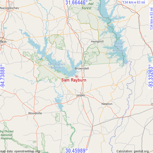
Sam Rayburn GPS coordinates[2]
31° 3' 50.688" North, 94° 2' 8.7" West
| Map corner | latitude | longitude |
|---|---|---|
| Upper-left | 31.66446°, | -94.73888° |
| Center: | 31.06408°, | -94.03575° |
| Lower-right: | 30.45989°, | -93.33263° |
| Map W x H: | 133.9×133.9 km | = 83.2×83.2mi |
| max Lat: | 71.29058° ⇑90.6% North |
| Sam Rayburn: | 31.06408° |
| min Lat: | ⇓9.4% South 19.06759° |
| min Long | Sam Rayburn | max Long |
| -171.73463° | -94.03575° | -66.98998° |
| W 31.3%⇐ | ⇒68.7% E |
Elevation
Elevation of Sam Rayburn is 67 m = 220 ft, and this is 227.8 m = 747 ft below average elevation for this country.
| Max E: |
3189 m = 10463 ft | 75.8% |
| Avg. | 294.8 m = 967 ft | |
| Sam Rayburn | 67 m = 220 ft | |
Min E: |
-60 m = -197 ft | 24.2% |
See also: United States elevation on elevation.city.
Geographical zone
Sam Rayburn is located in North temperate zone (between Tropic of Cancer and the Arctic Circle). Distance of this Northern Tropic circle is 848.1 km =527 mi to South.| Distance of | km | miles | from Sam Rayburn |
|---|---|---|---|
| North Pole | 6553.1 | 4071.9 | to North |
| Arctic Circle | 3947.2 | 2452.7 | to North |
| Tropic Cancer | 848.1 | 527 | to South |
| Equator | 3454 | 2146.2 | to South |


Nearby cities:
15 places around Sam Rayburn: (largest is in red/bold)
• Colmesneil
40.7 km =25.3 mi,  244°
244°
• Florien
69.3 km =43.1 mi,  52°
52°
• Hemphill
35.6 km =22.1 mi,  30°
30°
• Huntington
56.7 km =35.2 mi,  294°
294°
• Jasper
16.4 km =10.2 mi,  166°
166°
• Kirbyville
46.9 km =29.1 mi,  163°
163°
• Merryville
58.5 km =36.4 mi,  126°
126°
• Milam
44.8 km =27.8 mi,  23°
23°
• Newton
35.8 km =22.2 mi, 132°
• Pineland
21.3 km =13.2 mi, 15°
• San Augustine
52.2 km =32.4 mi,  352°
352°
• South Toledo Bend
42.2 km =26.2 mi,  76°
76°
• Warren
61.3 km =38.1 mi,  215°
215°
• Woodville
48.4 km =30.1 mi,  228°
228°
• Zavalla
38.6 km =24 mi, 285°
Sources, notices
• [Note1] Compared only with cities in United States existing in our database
• [Src1] Map data: © OpenStreetMap contributors (CC-BY-SA)
• [Src2] Other city data from geonames.org with taken over terms of usage.
• [Src3] Geographical zone / Annual Mean Temperature by Robert A. Rohde @ Wikipedia
