Pineland geodata
Pineland (Texas) is a populated place; located in United States in America/Chicago (GMT-5) time zone. With population of 813 people, there are 17692 cities with bigger population in this country. Compared to other cities in United States, 90.2% of cities are located further ↑North; 68.6% of cities are located further →East and 73.2% of cities have higher elevation than Pineland. Note1


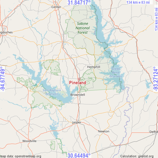
Pineland GPS coordinates[2]
31° 14' 52.692" North, 93° 58' 27.696" West
| Map corner | latitude | longitude |
|---|---|---|
| Upper-left | 31.84717°, | -94.67749° |
| Center: | 31.24797°, | -93.97436° |
| Lower-right: | 30.64494°, | -93.27124° |
| Map W x H: | 133.7×133.7 km | = 83.1×83.1mi |
| max Lat: | 71.29058° ⇑90.2% North |
| Pineland: | 31.24797° |
| min Lat: | ⇓9.8% South 19.06759° |
| min Long | Pineland | max Long |
| -171.73463° | -93.97436° | -66.98998° |
| W 31.4%⇐ | ⇒68.6% E |
Elevation
Elevation of Pineland is 82 m = 269 ft, and this is 212.8 m = 698 ft below average elevation for this country.
| Max E: |
3189 m = 10463 ft | 73.2% |
| Avg. | 294.8 m = 967 ft | |
| Pineland | 82 m = 269 ft | |
Min E: |
-60 m = -197 ft | 26.8% |
See also: United States elevation on elevation.city.
Geographical zone
Pineland is located in North temperate zone (between Tropic of Cancer and the Arctic Circle). Distance of this Northern Tropic circle is 868.5 km =539.7 mi to South.| Distance of | km | miles | from Pineland |
|---|---|---|---|
| North Pole | 6532.6 | 4059.2 | to North |
| Arctic Circle | 3926.7 | 2439.9 | to North |
| Tropic Cancer | 868.5 | 539.7 | to South |
| Equator | 3474.4 | 2158.9 | to South |


Nearby cities:
15 places around Pineland: (largest is in red/bold)
• Anacoco
60.2 km =37.4 mi,  89°
89°
• Center
63.9 km =39.7 mi,  342°
342°
• Colmesneil
57 km =35.4 mi,  228°
228°
• Florien
53.7 km =33.4 mi,  66°
66°
• Hemphill
15.9 km =9.9 mi,  49°
49°
• Huntington
57.3 km =35.6 mi,  273°
273°
• Jasper
36.5 km =22.7 mi,  183°
183°
• Many
58.6 km =36.4 mi, 52°
• Milam
23.9 km =14.9 mi,  30°
30°
• Newton
49 km =30.4 mi,  155°
155°
• Sam Rayburn
21.3 km =13.2 mi,  195°
195°
• San Augustine
33.7 km =20.9 mi, 338°
• South Toledo Bend
36.7 km =22.8 mi,  106°
106°
• Zavalla
44.1 km =27.4 mi,  256°
256°
• Zwolle
52.9 km =32.9 mi,  36°
36°
Sources, notices
• [Note1] Compared only with cities in United States existing in our database
• [Src1] Map data: © OpenStreetMap contributors (CC-BY-SA)
• [Src2] Other city data from geonames.org with taken over terms of usage.
• [Src3] Geographical zone / Annual Mean Temperature by Robert A. Rohde @ Wikipedia
