Breckenridge geodata
Breckenridge (Minnesota) is a seat of a second-order administrative division; located in United States in America/Chicago (GMT-5) time zone. With population of 3,290 people, there are 9169 cities with bigger population in this country. Compared to other cities in United States, 95.4% of cities are located further ↓South; 74.7% of cities are located further →East and 71.1% of cities have lower elevation than Breckenridge. Note1


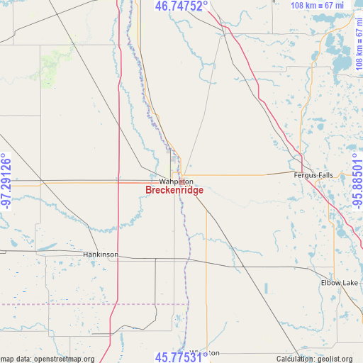
Breckenridge GPS coordinates[2]
46° 15' 48.852" North, 96° 35' 17.268" West
| Map corner | latitude | longitude |
|---|---|---|
| Upper-left | 46.74752°, | -97.29126° |
| Center: | 46.26357°, | -96.58813° |
| Lower-right: | 45.77531°, | -95.88501° |
| Map W x H: | 108.1×108.1 km | = 67.2×67.2mi |
| max Lat: | 71.29058° ⇑4.6% North |
| Breckenridge: | 46.26357° |
| min Lat: | ⇓95.4% South 19.06759° |
| min Long | Breckenridge | max Long |
| -171.73463° | -96.58813° | -66.98998° |
| W 25.3%⇐ | ⇒74.7% E |
Elevation
Elevation of Breckenridge is 291 m = 955 ft, and this is 3.8 m = 12 ft below average elevation for this country.
| Max E: |
3189 m = 10463 ft | 28.9% |
| Avg. | 294.8 m = 967 ft | |
| Breckenridge | 291 m = 955 ft | |
Min E: |
-60 m = -197 ft | 71.1% |
See also: United States elevation on elevation.city.
Geographical zone
Breckenridge is located in North temperate zone (between Tropic of Cancer and the Arctic Circle). Distance of this North polar circle is 2257.1 km =1402.5 mi to North.| Distance of | km | miles | from Breckenridge |
|---|---|---|---|
| North Pole | 4863 | 3021.7 | to North |
| Arctic Circle | 2257.1 | 1402.5 | to North |
| Tropic Cancer | 2538.1 | 1577.1 | to South |
| Equator | 5144 | 3196.3 | to South |


Nearby cities:
15 places around Breckenridge: (largest is in red/bold)
• Barnesville
45.1 km =28 mi,  16°
16°
• Battle Lake
67.2 km =41.8 mi,  88°
88°
• Dilworth
68.7 km =42.7 mi,  352°
352°
• Elbow Lake
55.8 km =34.7 mi,  122°
122°
• Fergus Falls
39.3 km =24.4 mi, 86°
• Glyndon
68 km =42.3 mi,  0°
0°
• Hankinson
32.4 km =20.1 mi,  228°
228°
• Horace
60.1 km =37.3 mi,  336°
336°
• Kindred
54 km =33.6 mi,  322°
322°
• Lidgerwood
48.2 km =30 mi,  244°
244°
• Milnor
66.7 km =41.4 mi,  269°
269°
• Pelican Rapids
51.6 km =32.1 mi,  48°
48°
• Sabin
57.6 km =35.8 mi,  355°
355°
• Wahpeton
1.4 km =0.9 mi,  277°
277°
• Wheaton
51.5 km =32 mi,  172°
172°
Sources, notices
• [Note1] Compared only with cities in United States existing in our database
• [Src1] Map data: © OpenStreetMap contributors (CC-BY-SA)
• [Src2] Other city data from geonames.org with taken over terms of usage.
• [Src3] Geographical zone / Annual Mean Temperature by Robert A. Rohde @ Wikipedia
