Crookston geodata
Crookston (Minnesota) is a seat of a second-order administrative division; located in United States in America/Chicago (GMT-5) time zone. With population of 7,787 people, there are 5389 cities with bigger population in this country. Compared to other cities in United States, 98.2% of cities are located further ↓South; 74.7% of cities are located further →East and 65.8% of cities have lower elevation than Crookston. Note1


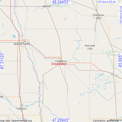
Crookston GPS coordinates[2]
47° 46' 26.904" North, 96° 36' 29.232" West
| Map corner | latitude | longitude |
|---|---|---|
| Upper-left | 48.24453°, | -97.31125° |
| Center: | 47.77414°, | -96.60812° |
| Lower-right: | 47.29945°, | -95.905° |
| Map W x H: | 105.1×105.1 km | = 65.3×65.3mi |
| max Lat: | 71.29058° ⇑1.8% North |
| Crookston: | 47.77414° |
| min Lat: | ⇓98.2% South 19.06759° |
| min Long | Crookston | max Long |
| -171.73463° | -96.60812° | -66.98998° |
| W 25.3%⇐ | ⇒74.7% E |
Elevation
Elevation of Crookston is 266 m = 873 ft, and this is 28.8 m = 94 ft below average elevation for this country.
| Max E: |
3189 m = 10463 ft | 34.2% |
| Avg. | 294.8 m = 967 ft | |
| Crookston | 266 m = 873 ft | |
Min E: |
-60 m = -197 ft | 65.8% |
See also: United States elevation on elevation.city.
Geographical zone
Crookston is located in North temperate zone (between Tropic of Cancer and the Arctic Circle). Distance of this North polar circle is 2089.2 km =1298.2 mi to North.| Distance of | km | miles | from Crookston |
|---|---|---|---|
| North Pole | 4695.1 | 2917.4 | to North |
| Arctic Circle | 2089.2 | 1298.2 | to North |
| Tropic Cancer | 2706.1 | 1681.5 | to South |
| Equator | 5312 | 3300.7 | to South |


Nearby cities:
15 places around Crookston: (largest is in red/bold)
• Ada
53.2 km =33.1 mi,  172°
172°
• Argyle
64.1 km =39.8 mi,  345°
345°
• East Grand Forks
35.6 km =22.1 mi,  299°
299°
• Fertile
36.1 km =22.4 mi,  137°
137°
• Grand Forks
35.9 km =22.3 mi, 297°
• Grand Forks Air Force Base
61.5 km =38.2 mi,  289°
289°
• Halstad
49.8 km =30.9 mi,  199°
199°
• Hillsboro
53.4 km =33.2 mi,  219°
219°
• Mayville
61.8 km =38.4 mi,  240°
240°
• McIntosh
56.1 km =34.9 mi,  105°
105°
• Red Lake Falls
27.7 km =17.2 mi,  64°
64°
• Thief River Falls
49.8 km =30.9 mi,  39°
39°
• Thompson
37.5 km =23.3 mi,  269°
269°
• Twin Valley
62.9 km =39.1 mi,  155°
155°
• Warren
48.6 km =30.2 mi, 345°
Sources, notices
• [Note1] Compared only with cities in United States existing in our database
• [Src1] Map data: © OpenStreetMap contributors (CC-BY-SA)
• [Src2] Other city data from geonames.org with taken over terms of usage.
• [Src3] Geographical zone / Annual Mean Temperature by Robert A. Rohde @ Wikipedia
