Mayville geodata
Mayville (North Dakota) is a populated place; located in United States in America/Chicago (GMT-5) time zone. With population of 1,829 people, there are 12438 cities with bigger population in this country. Compared to other cities in United States, 97.6% of cities are located further ↓South; 76.7% of cities are located further →East and 72.8% of cities have lower elevation than Mayville. Note1


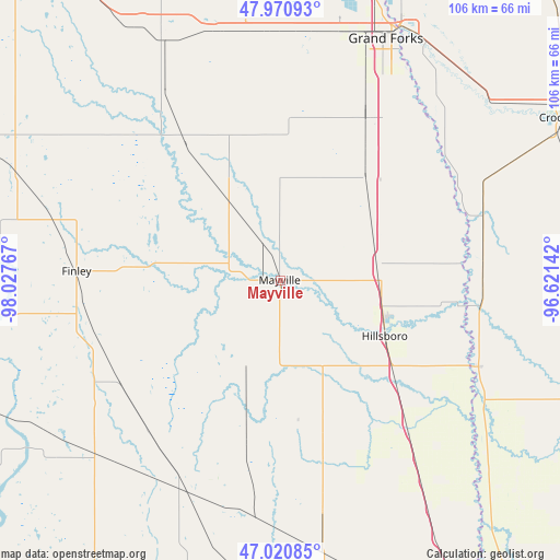
Mayville GPS coordinates[2]
47° 29' 52.944" North, 97° 19' 28.344" West
| Map corner | latitude | longitude |
|---|---|---|
| Upper-left | 47.97093°, | -98.02767° |
| Center: | 47.49804°, | -97.32454° |
| Lower-right: | 47.02085°, | -96.62142° |
| Map W x H: | 105.6×105.6 km | = 65.6×65.6mi |
| max Lat: | 71.29058° ⇑2.4% North |
| Mayville: | 47.49804° |
| min Lat: | ⇓97.6% South 19.06759° |
| min Long | Mayville | max Long |
| -171.73463° | -97.32454° | -66.98998° |
| W 23.3%⇐ | ⇒76.7% E |
Elevation
Elevation of Mayville is 300 m = 984 ft, and this is 5.2 m = 17 ft above average elevation for this country.
| Max E: |
3189 m = 10463 ft | 27.2% |
| Mayville | 300 m 984 ft | |
| Avg. | 294.8 m = 967 ft | |
Min E: |
-60 m = -197 ft | 72.8% |
See also: United States elevation on elevation.city.
Geographical zone
Mayville is located in North temperate zone (between Tropic of Cancer and the Arctic Circle). Distance of this North polar circle is 2119.9 km =1317.2 mi to North.| Distance of | km | miles | from Mayville |
|---|---|---|---|
| North Pole | 4725.8 | 2936.5 | to North |
| Arctic Circle | 2119.9 | 1317.2 | to North |
| Tropic Cancer | 2675.4 | 1662.4 | to South |
| Equator | 5281.3 | 3281.6 | to South |


Nearby cities:
15 places around Mayville: (largest is in red/bold)
• Ada
64.8 km =40.3 mi,  109°
109°
• Cooperstown
60.4 km =37.5 mi,  264°
264°
• Crookston
61.8 km =38.4 mi,  60°
60°
• East Grand Forks
53 km =32.9 mi,  25°
25°
• Finley
38.5 km =23.9 mi,  272°
272°
• Grand Forks
52.3 km =32.5 mi,  24°
24°
• Grand Forks Air Force Base
51 km =31.7 mi,  354°
354°
• Halstad
40.7 km =25.3 mi, 113°
• Harwood
66.7 km =41.4 mi,  149°
149°
• Hatton
18.5 km =11.5 mi,  328°
328°
• Hillsboro
22.3 km =13.9 mi,  117°
117°
• Larimore
50.8 km =31.6 mi, 333°
• Northwood
31.9 km =19.8 mi, 325°
• Portland
3.4 km =2.1 mi, 270°
• Thompson
34.6 km =21.5 mi, 27°
Sources, notices
• [Note1] Compared only with cities in United States existing in our database
• [Src1] Map data: © OpenStreetMap contributors (CC-BY-SA)
• [Src2] Other city data from geonames.org with taken over terms of usage.
• [Src3] Geographical zone / Annual Mean Temperature by Robert A. Rohde @ Wikipedia
