Plum City geodata
Plum City (Wisconsin) is a populated place; located in United States in America/Chicago (GMT-5) time zone. With population of 578 people, there are 19937 cities with bigger population in this country. Compared to other cities in United States, 91% of cities are located further ↓South; 64.6% of cities are located further →East and 62.1% of cities have lower elevation than Plum City. Note1


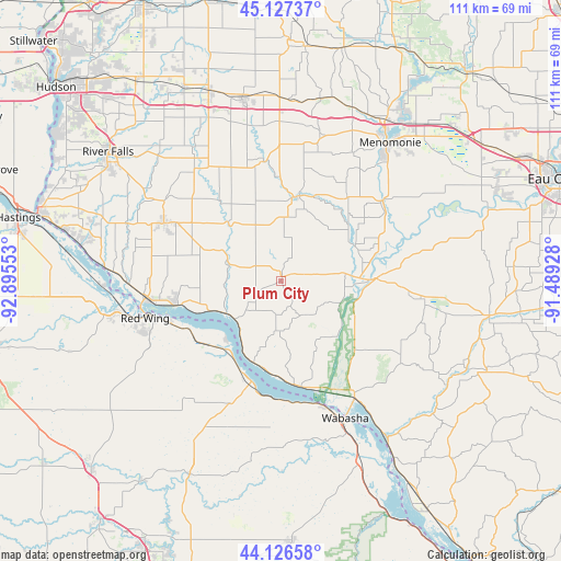
Plum City GPS coordinates[2]
44° 37' 44.868" North, 92° 11' 32.64" West
| Map corner | latitude | longitude |
|---|---|---|
| Upper-left | 45.12737°, | -92.89553° |
| Center: | 44.62913°, | -92.1924° |
| Lower-right: | 44.12658°, | -91.48928° |
| Map W x H: | 111.3×111.3 km | = 69.2×69.2mi |
| max Lat: | 71.29058° ⇑9% North |
| Plum City: | 44.62913° |
| min Lat: | ⇓91% South 19.06759° |
| min Long | Plum City | max Long |
| -171.73463° | -92.1924° | -66.98998° |
| W 35.4%⇐ | ⇒64.6% E |
Elevation
Elevation of Plum City is 249 m = 817 ft, and this is 45.8 m = 150 ft below average elevation for this country.
| Max E: |
3189 m = 10463 ft | 37.9% |
| Avg. | 294.8 m = 967 ft | |
| Plum City | 249 m = 817 ft | |
Min E: |
-60 m = -197 ft | 62.1% |
See also: United States elevation on elevation.city.
Geographical zone
Plum City is located in North temperate zone (between Tropic of Cancer and the Arctic Circle). Distance of this Northern Tropic circle is 2356.4 km =1464.2 mi to South.| Distance of | km | miles | from Plum City |
|---|---|---|---|
| North Pole | 5044.8 | 3134.7 | to North |
| Arctic Circle | 2438.9 | 1515.5 | to North |
| Tropic Cancer | 2356.4 | 1464.2 | to South |
| Equator | 4962.3 | 3083.4 | to South |


Nearby cities:
15 places around Plum City: (largest is in red/bold)
• Alma
40.8 km =25.4 mi,  147°
147°
• Baldwin
40.2 km =25 mi,  339°
339°
• Durand
17.9 km =11.1 mi,  90°
90°
• El Paso
19.7 km =12.2 mi,  322°
322°
• Ellsworth
26 km =16.2 mi,  296°
296°
• Elmwood
17.3 km =10.7 mi,  12°
12°
• Goodhue
42.6 km =26.5 mi,  233°
233°
• Lake City
20.8 km =12.9 mi,  196°
196°
• Menomonie
34.9 km =21.7 mi,  38°
38°
• Mondovi
41.8 km =26 mi,  99°
99°
• Pepin
21.2 km =13.2 mi,  170°
170°
• Red Wing
28 km =17.4 mi,  254°
254°
• Spring Valley
24.3 km =15.1 mi,  351°
351°
• Wabasha
30.1 km =18.7 mi,  155°
155°
• Woodville
36.8 km =22.9 mi, 347°
Sources, notices
• [Note1] Compared only with cities in United States existing in our database
• [Src1] Map data: © OpenStreetMap contributors (CC-BY-SA)
• [Src2] Other city data from geonames.org with taken over terms of usage.
• [Src3] Geographical zone / Annual Mean Temperature by Robert A. Rohde @ Wikipedia
