Pepin geodata
Pepin (Wisconsin) is a populated place; located in United States in America/Chicago (GMT-5) time zone. With population of 795 people, there are 17856 cities with bigger population in this country. Compared to other cities in United States, 90.2% of cities are located further ↓South; 64.4% of cities are located further →East and 55.4% of cities have lower elevation than Pepin. Note1


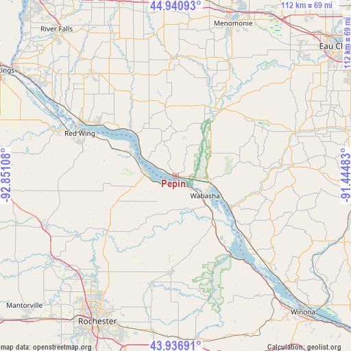
Pepin GPS coordinates[2]
44° 26' 27.888" North, 92° 8' 52.62" West
| Map corner | latitude | longitude |
|---|---|---|
| Upper-left | 44.94093°, | -92.85108° |
| Center: | 44.44108°, | -92.14795° |
| Lower-right: | 43.93691°, | -91.44483° |
| Map W x H: | 111.6×111.6 km | = 69.3×69.3mi |
| max Lat: | 71.29058° ⇑9.8% North |
| Pepin: | 44.44108° |
| min Lat: | ⇓90.2% South 19.06759° |
| min Long | Pepin | max Long |
| -171.73463° | -92.14795° | -66.98998° |
| W 35.6%⇐ | ⇒64.4% E |
Elevation
Elevation of Pepin is 220 m = 722 ft, and this is 74.8 m = 245 ft below average elevation for this country.
| Max E: |
3189 m = 10463 ft | 44.6% |
| Avg. | 294.8 m = 967 ft | |
| Pepin | 220 m = 722 ft | |
Min E: |
-60 m = -197 ft | 55.4% |
See also: United States elevation on elevation.city.
Geographical zone
Pepin is located in North temperate zone (between Tropic of Cancer and the Arctic Circle). Distance of this Northern Tropic circle is 2335.5 km =1451.2 mi to South.| Distance of | km | miles | from Pepin |
|---|---|---|---|
| North Pole | 5065.7 | 3147.7 | to North |
| Arctic Circle | 2459.8 | 1528.4 | to North |
| Tropic Cancer | 2335.5 | 1451.2 | to South |
| Equator | 4941.4 | 3070.4 | to South |


Nearby cities:
15 places around Pepin: (largest is in red/bold)
• Alma
22.9 km =14.2 mi,  126°
126°
• Buffalo City
32.5 km =20.2 mi,  136°
136°
• Durand
25.2 km =15.7 mi,  35°
35°
• El Paso
39.7 km =24.7 mi,  336°
336°
• Elgin
35.5 km =22.1 mi,  193°
193°
• Ellsworth
42.1 km =26.2 mi,  320°
320°
• Elmwood
37.8 km =23.5 mi,  0°
0°
• Goodhue
38.1 km =23.7 mi,  263°
263°
• Lake City
9.6 km =6 mi,  275°
275°
• Mazeppa
36.7 km =22.8 mi,  239°
239°
• Mondovi
40.4 km =25.1 mi,  69°
69°
• Plainview
30.8 km =19.1 mi,  183°
183°
• Plum City
21.2 km =13.2 mi,  350°
350°
• Red Wing
33.4 km =20.8 mi,  293°
293°
• Wabasha
11.1 km =6.9 mi,  124°
124°
Sources, notices
• [Note1] Compared only with cities in United States existing in our database
• [Src1] Map data: © OpenStreetMap contributors (CC-BY-SA)
• [Src2] Other city data from geonames.org with taken over terms of usage.
• [Src3] Geographical zone / Annual Mean Temperature by Robert A. Rohde @ Wikipedia
