Valle Vista geodata
Valle Vista (Arizona) is a populated place; located in United States in America/Phoenix (GMT-7) time zone. With population of 1,659 people, there are 13052 cities with bigger population in this country. Compared to other cities in United States, 73.1% of cities are located further ↑North; 88.4% of cities are located further →East and 93.2% of cities have lower elevation than Valle Vista. Note1


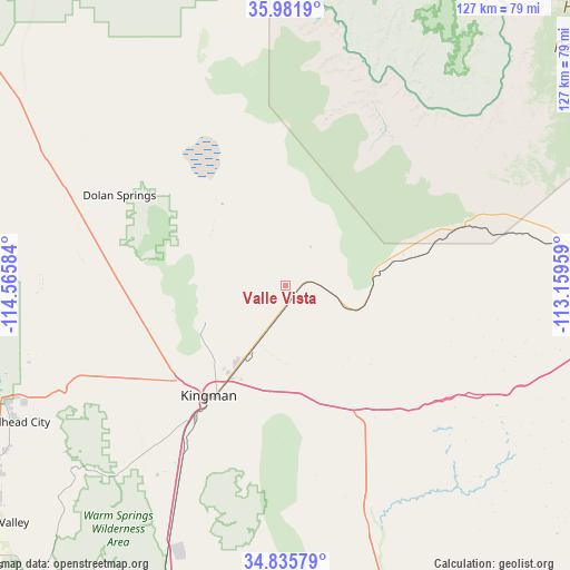
Valle Vista GPS coordinates[2]
35° 24' 39.168" North, 113° 51' 45.756" West
| Map corner | latitude | longitude |
|---|---|---|
| Upper-left | 35.9819°, | -114.56584° |
| Center: | 35.41088°, | -113.86271° |
| Lower-right: | 34.83579°, | -113.15959° |
| Map W x H: | 127.4×127.4 km | = 79.2×79.2mi |
| max Lat: | 71.29058° ⇑73.1% North |
| Valle Vista: | 35.41088° |
| min Lat: | ⇓26.9% South 19.06759° |
| min Long | Valle Vista | max Long |
| -171.73463° | -113.86271° | -66.98998° |
| W 11.6%⇐ | ⇒88.4% E |
Elevation
Elevation of Valle Vista is 969 m = 3179 ft, and this is 674.2 m = 2212 ft above average elevation for this country.
| Max E: |
3189 m = 10463 ft | 6.8% |
| Valle Vista | 969 m 3179 ft | |
| Avg. | 294.8 m = 967 ft | |
Min E: |
-60 m = -197 ft | 93.2% |
See also: United States elevation on elevation.city.
Geographical zone
Valle Vista is located in North temperate zone (between Tropic of Cancer and the Arctic Circle). Distance of this Northern Tropic circle is 1331.4 km =827.3 mi to South.| Distance of | km | miles | from Valle Vista |
|---|---|---|---|
| North Pole | 6069.7 | 3771.5 | to North |
| Arctic Circle | 3463.9 | 2152.4 | to North |
| Tropic Cancer | 1331.4 | 827.3 | to South |
| Equator | 3937.3 | 2446.5 | to South |


Nearby cities:
15 places around Valle Vista: (largest is in red/bold)
• Arizona Village
90.3 km =56.1 mi,  226°
226°
• Bullhead City
70.4 km =43.7 mi,  245°
245°
• Dolan Springs
42.3 km =26.3 mi,  298°
298°
• Golden Shores
89.6 km =55.7 mi,  218°
218°
• Golden Valley
38.8 km =24.1 mi,  237°
237°
• Kingman
30.1 km =18.7 mi, 215°
• Laughlin
69.9 km =43.4 mi, 247°
• Meadview
68.3 km =42.4 mi,  344°
344°
• Mohave Valley
84.7 km =52.6 mi, 231°
• Needles
92.7 km =57.6 mi, 227°
• New Kingman-Butler
22.3 km =13.9 mi, 223°
• Peach Springs
41.7 km =25.9 mi,  71°
71°
• Searchlight
95.9 km =59.6 mi,  273°
273°
• Walnut Creek
39.3 km =24.4 mi, 217°
• Willow Valley
87.5 km =54.4 mi, 230°
Sources, notices
• [Note1] Compared only with cities in United States existing in our database
• [Src1] Map data: © OpenStreetMap contributors (CC-BY-SA)
• [Src2] Other city data from geonames.org with taken over terms of usage.
• [Src3] Geographical zone / Annual Mean Temperature by Robert A. Rohde @ Wikipedia
