Stanfield geodata
Stanfield (Arizona) is a populated place; located in United States in America/Phoenix (GMT-7) time zone. With population of 740 people, there are 18306 cities with bigger population in this country. Compared to other cities in United States, 85.6% of cities are located further ↑North; 87.4% of cities are located further →East and 83.3% of cities have lower elevation than Stanfield. Note1


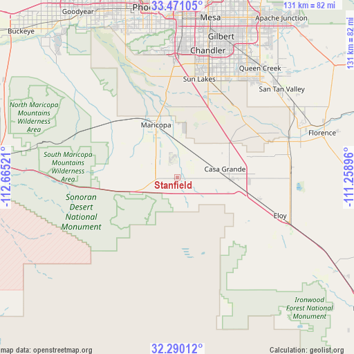
Stanfield GPS coordinates[2]
32° 52' 57.18" North, 111° 57' 43.488" West
| Map corner | latitude | longitude |
|---|---|---|
| Upper-left | 33.47105°, | -112.66521° |
| Center: | 32.88255°, | -111.96208° |
| Lower-right: | 32.29012°, | -111.25896° |
| Map W x H: | 131.3×131.3 km | = 81.6×81.6mi |
| max Lat: | 71.29058° ⇑85.6% North |
| Stanfield: | 32.88255° |
| min Lat: | ⇓14.4% South 19.06759° |
| min Long | Stanfield | max Long |
| -171.73463° | -111.96208° | -66.98998° |
| W 12.6%⇐ | ⇒87.4% E |
Elevation
Elevation of Stanfield is 395 m = 1296 ft, and this is 100.2 m = 329 ft above average elevation for this country.
| Max E: |
3189 m = 10463 ft | 16.7% |
| Stanfield | 395 m 1296 ft | |
| Avg. | 294.8 m = 967 ft | |
Min E: |
-60 m = -197 ft | 83.3% |
See also: United States elevation on elevation.city.
Geographical zone
Stanfield is located in North temperate zone (between Tropic of Cancer and the Arctic Circle). Distance of this Northern Tropic circle is 1050.3 km =652.6 mi to South.| Distance of | km | miles | from Stanfield |
|---|---|---|---|
| North Pole | 6350.9 | 3946.3 | to North |
| Arctic Circle | 3745 | 2327 | to North |
| Tropic Cancer | 1050.3 | 652.6 | to South |
| Equator | 3656.2 | 2271.9 | to South |


Nearby cities:
15 places around Stanfield: (largest is in red/bold)
• Ak-Chin Village
20 km =12.4 mi,  324°
324°
• Arizona City
30.6 km =19 mi,  117°
117°
• Blackwater
39.1 km =24.3 mi,  64°
64°
• Casa Blanca
27.3 km =17 mi,  14°
14°
• Casa Grande
19.1 km =11.9 mi,  91°
91°
• Chandler
48.4 km =30.1 mi, 13°
• Coolidge
42.8 km =26.6 mi,  75°
75°
• Eloy
40.6 km =25.2 mi,  110°
110°
• Gila Crossing
47.8 km =29.7 mi,  336°
336°
• Komatke
49.8 km =30.9 mi, 336°
• Maricopa
21.1 km =13.1 mi, 337°
• Queen Creek
50.9 km =31.6 mi,  36°
36°
• Sacaton
30 km =18.6 mi, 43°
• Santan
36 km =22.4 mi,  24°
24°
• Sun Lakes
37.4 km =23.2 mi, 12°
Sources, notices
• [Note1] Compared only with cities in United States existing in our database
• [Src1] Map data: © OpenStreetMap contributors (CC-BY-SA)
• [Src2] Other city data from geonames.org with taken over terms of usage.
• [Src3] Geographical zone / Annual Mean Temperature by Robert A. Rohde @ Wikipedia
