Ak-Chin Village geodata
Ak-Chin Village (Arizona) is a populated place; located in United States in America/Phoenix (GMT-7) time zone. With population of 862 people, there are 17264 cities with bigger population in this country. Compared to other cities in United States, 85% of cities are located further ↑North; 87.7% of cities are located further →East and 81% of cities have lower elevation than Ak-Chin Village. Note1


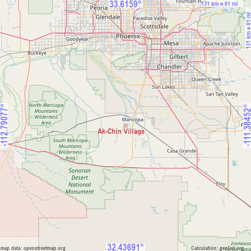
Ak-Chin Village GPS coordinates[2]
33° 1' 42.168" North, 112° 5' 15.504" West
| Map corner | latitude | longitude |
|---|---|---|
| Upper-left | 33.6159°, | -112.79077° |
| Center: | 33.02838°, | -112.08764° |
| Lower-right: | 32.43691°, | -111.38452° |
| Map W x H: | 131.1×131.1 km | = 81.5×81.5mi |
| max Lat: | 71.29058° ⇑85% North |
| Ak-Chin Village: | 33.02838° |
| min Lat: | ⇓15% South 19.06759° |
| min Long | Ak-Chin Village | max Long |
| -171.73463° | -112.08764° | -66.98998° |
| W 12.3%⇐ | ⇒87.7% E |
Elevation
Elevation of Ak-Chin Village is 365 m = 1198 ft, and this is 70.2 m = 230 ft above average elevation for this country.
| Max E: |
3189 m = 10463 ft | 19% |
| Ak-Chin Village | 365 m 1198 ft | |
| Avg. | 294.8 m = 967 ft | |
Min E: |
-60 m = -197 ft | 81% |
See also: United States elevation on elevation.city.
Geographical zone
Ak-Chin Village is located in North temperate zone (between Tropic of Cancer and the Arctic Circle). Distance of this Northern Tropic circle is 1066.5 km =662.7 mi to South.| Distance of | km | miles | from Ak-Chin Village |
|---|---|---|---|
| North Pole | 6334.7 | 3936.2 | to North |
| Arctic Circle | 3728.8 | 2317 | to North |
| Tropic Cancer | 1066.5 | 662.7 | to South |
| Equator | 3672.4 | 2281.9 | to South |


Nearby cities:
15 places around Ak-Chin Village: (largest is in red/bold)
• Ahwatukee Foothills
36.1 km =22.4 mi,  15°
15°
• Casa Blanca
21.2 km =13.2 mi,  61°
61°
• Casa Grande
35 km =21.7 mi,  118°
118°
• Chandler
38.5 km =23.9 mi,  36°
36°
• Gila Crossing
28.6 km =17.8 mi,  345°
345°
• Guadalupe
39.8 km =24.7 mi, 16°
• Komatke
30.6 km =19 mi,  344°
344°
• Laveen
38 km =23.6 mi, 348°
• Maricopa
5 km =3.1 mi,  48°
48°
• Sacaton
32.9 km =20.4 mi,  80°
80°
• San Carlos
41.6 km =25.8 mi,  31°
31°
• Santan
31.5 km =19.6 mi, 58°
• Stanfield
20 km =12.4 mi,  144°
144°
• Sun Lakes
28.3 km =17.6 mi, 44°
• Tempe Junction
44.9 km =27.9 mi, 17°
Sources, notices
• [Note1] Compared only with cities in United States existing in our database
• [Src1] Map data: © OpenStreetMap contributors (CC-BY-SA)
• [Src2] Other city data from geonames.org with taken over terms of usage.
• [Src3] Geographical zone / Annual Mean Temperature by Robert A. Rohde @ Wikipedia
