Piñon Hills geodata
Piñon Hills (California) is a populated place; located in United States in America/Los_Angeles (GMT-7) time zone. With population of 7,272 people, there are 5666 cities with bigger population in this country. Compared to other cities in United States, 78% of cities are located further ↑North; 90.5% of cities are located further →East and 95.1% of cities have lower elevation than Piñon Hills. Note1


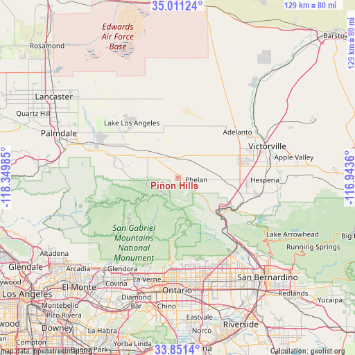
Piñon Hills GPS coordinates[2]
34° 25' 59.988" North, 117° 38' 48.192" West
| Map corner | latitude | longitude |
|---|---|---|
| Upper-left | 35.01124°, | -118.34985° |
| Center: | 34.43333°, | -117.64672° |
| Lower-right: | 33.8514°, | -116.9436° |
| Map W x H: | 129×129 km | = 80.2×80.2mi |
| max Lat: | 71.29058° ⇑78% North |
| Piñon Hills: | 34.43333° |
| min Lat: | ⇓22% South 19.06759° |
| min Long | Piñon Hills | max Long |
| -171.73463° | -117.64672° | -66.98998° |
| W 9.5%⇐ | ⇒90.5% E |
Elevation
Elevation of Piñon Hills is 1274 m = 4180 ft, and this is 979.2 m = 3213 ft above average elevation for this country.
| Max E: |
3189 m = 10463 ft | 4.9% |
| Piñon Hills | 1274 m 4180 ft | |
| Avg. | 294.8 m = 967 ft | |
Min E: |
-60 m = -197 ft | 95.1% |
See also: United States elevation on elevation.city.
Geographical zone
Piñon Hills is located in North temperate zone (between Tropic of Cancer and the Arctic Circle). Distance of this Northern Tropic circle is 1222.7 km =759.8 mi to South.| Distance of | km | miles | from Piñon Hills |
|---|---|---|---|
| North Pole | 6178.4 | 3839.1 | to North |
| Arctic Circle | 3572.5 | 2219.8 | to North |
| Tropic Cancer | 1222.7 | 759.8 | to South |
| Equator | 3828.6 | 2379 | to South |


Nearby cities:
15 places around Piñon Hills: (largest is in red/bold)
• Adelanto
27.4 km =17 mi,  52°
52°
• Hesperia
31.7 km =19.7 mi,  91°
91°
• Lake Los Angeles
25.9 km =16.1 mi,  320°
320°
• Littlerock
32.4 km =20.1 mi,  287°
287°
• Lytle Creek
23.6 km =14.7 mi,  145°
145°
• Mountain View Acres
28.2 km =17.5 mi,  75°
75°
• Oak Hills
25 km =15.5 mi,  102°
102°
• Phelan
6.9 km =4.3 mi, 96°
• Rancho Cucamonga
36.7 km =22.8 mi,  172°
172°
• San Antonio Heights
30.9 km =19.2 mi,  181°
181°
• Spring Valley Lake
35.3 km =21.9 mi, 79°
• Sun Village
31.7 km =19.7 mi,  296°
296°
• Upland
37.3 km =23.2 mi, 180°
• Victorville
34.5 km =21.4 mi,  70°
70°
• Wrightwood
8.2 km =5.1 mi, 171°
Sources, notices
• [Note1] Compared only with cities in United States existing in our database
• [Src1] Map data: © OpenStreetMap contributors (CC-BY-SA)
• [Src2] Other city data from geonames.org with taken over terms of usage.
• [Src3] Geographical zone / Annual Mean Temperature by Robert A. Rohde @ Wikipedia
