Wrightwood geodata
Wrightwood (California) is a populated place; located in United States in America/Los_Angeles (GMT-7) time zone. With population of 4,525 people, there are 7619 cities with bigger population in this country. Compared to other cities in United States, 78.2% of cities are located further ↑North; 90.5% of cities are located further →East and 98.5% of cities have lower elevation than Wrightwood. Note1


Wrightwood GPS coordinates[2]
34° 21' 38.988" North, 117° 38' 0.204" West
| Map corner | latitude | longitude |
|---|---|---|
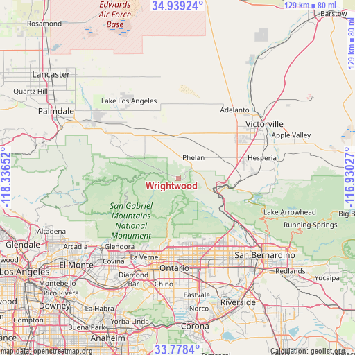
| Upper-left | 34.93924°, | -118.33652° |
| Center: | 34.36083°, | -117.63339° |
| Lower-right: | 33.7784°, | -116.93027° |
| Map W x H: | 129.1×129.1 km | = 80.2×80.2mi |
| max Lat: | 71.29058° ⇑78.2% North |
| Wrightwood: | 34.36083° |
| min Lat: | ⇓21.8% South 19.06759° |
| min Long | Wrightwood | max Long |
| -171.73463° | -117.63339° | -66.98998° |
| W 9.5%⇐ | ⇒90.5% E |
Elevation
Elevation of Wrightwood is 1816 m = 5958 ft, and this is 1521.2 m = 4991 ft above average elevation for this country.
| Max E: |
3189 m = 10463 ft | 1.5% |
| Wrightwood | 1816 m 5958 ft | |
| Avg. | 294.8 m = 967 ft | |
Min E: |
-60 m = -197 ft | 98.5% |
See also: United States elevation on elevation.city.
Geographical zone
Wrightwood is located in North temperate zone (between Tropic of Cancer and the Arctic Circle). Distance of this Northern Tropic circle is 1214.6 km =754.7 mi to South.| Distance of | km | miles | from Wrightwood |
|---|---|---|---|
| North Pole | 6186.5 | 3844.1 | to North |
| Arctic Circle | 3580.6 | 2224.9 | to North |
| Tropic Cancer | 1214.6 | 754.7 | to South |
| Equator | 3820.6 | 2374 | to South |


Nearby cities:
15 places around Wrightwood: (largest is in red/bold)
• Adelanto
32.1 km =19.9 mi,  39°
39°
• Claremont
30.4 km =18.9 mi,  195°
195°
• Glendora
32.8 km =20.4 mi,  220°
220°
• Hesperia
31.4 km =19.5 mi,  76°
76°
• La Verne
31.4 km =19.5 mi, 203°
• Lytle Creek
16.7 km =10.4 mi,  132°
132°
• Montclair
31.9 km =19.8 mi,  189°
189°
• Mountain View Acres
30.1 km =18.7 mi,  59°
59°
• Oak Hills
23.3 km =14.5 mi, 83°
• Phelan
9.2 km =5.7 mi, 37°
• Piñon Hills
8.2 km =5.1 mi,  351°
351°
• Rancho Cucamonga
28.5 km =17.7 mi,  172°
172°
• San Antonio Heights
22.9 km =14.2 mi, 185°
• San Dimas
32.4 km =20.1 mi,  209°
209°
• Upland
29.3 km =18.2 mi,  182°
182°
Sources, notices
• [Note1] Compared only with cities in United States existing in our database
• [Src1] Map data: © OpenStreetMap contributors (CC-BY-SA)
• [Src2] Other city data from geonames.org with taken over terms of usage.
• [Src3] Geographical zone / Annual Mean Temperature by Robert A. Rohde @ Wikipedia
