Huron geodata
Huron (California) is a populated place; located in United States in America/Los_Angeles (GMT-7) time zone. With population of 6,836 people, there are 5901 cities with bigger population in this country. Compared to other cities in United States, 69.4% of cities are located further ↑North; 92.9% of cities are located further →East and 68.3% of cities have higher elevation than Huron. Note1


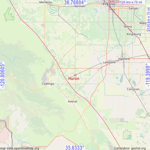
Huron GPS coordinates[2]
36° 12' 9.828" North, 120° 6' 10.512" West
| Map corner | latitude | longitude |
|---|---|---|
| Upper-left | 36.76804°, | -120.80605° |
| Center: | 36.20273°, | -120.10292° |
| Lower-right: | 35.6333°, | -119.3998° |
| Map W x H: | 126.2×126.2 km | = 78.4×78.4mi |
| max Lat: | 71.29058° ⇑69.4% North |
| Huron: | 36.20273° |
| min Lat: | ⇓30.6% South 19.06759° |
| min Long | Huron | max Long |
| -171.73463° | -120.10292° | -66.98998° |
| W 7.1%⇐ | ⇒92.9% E |
Elevation
Elevation of Huron is 111 m = 364 ft, and this is 183.8 m = 603 ft below average elevation for this country.
| Max E: |
3189 m = 10463 ft | 68.3% |
| Avg. | 294.8 m = 967 ft | |
| Huron | 111 m = 364 ft | |
Min E: |
-60 m = -197 ft | 31.7% |
See also: United States elevation on elevation.city.
Geographical zone
Huron is located in North temperate zone (between Tropic of Cancer and the Arctic Circle). Distance of this Northern Tropic circle is 1419.4 km =882 mi to South.| Distance of | km | miles | from Huron |
|---|---|---|---|
| North Pole | 5981.7 | 3716.9 | to North |
| Arctic Circle | 3375.8 | 2097.6 | to North |
| Tropic Cancer | 1419.4 | 882 | to South |
| Equator | 4025.4 | 2501.3 | to South |


Nearby cities:
15 places around Huron: (largest is in red/bold)
• Armona
37.5 km =23.3 mi,  70°
70°
• Avenal
22.2 km =13.8 mi,  186°
186°
• Caruthers
44.9 km =27.9 mi,  32°
32°
• Coalinga
24.1 km =15 mi,  253°
253°
• Hanford
43.3 km =26.9 mi, 71°
• Home Garden
43.3 km =26.9 mi,  75°
75°
• Kettleman City
25.1 km =15.6 mi,  149°
149°
• Lanare
29.6 km =18.4 mi, 31°
• Laton
45.2 km =28.1 mi,  55°
55°
• Lemoore
30.7 km =19.1 mi, 69°
• Lemoore Station
19 km =11.8 mi, 69°
• Lucerne
44 km =27.3 mi, 63°
• Riverdale
33.5 km =20.8 mi,  40°
40°
• San Joaquin
45.6 km =28.3 mi,  350°
350°
• Stratford
25.1 km =15.6 mi,  93°
93°
Sources, notices
• [Note1] Compared only with cities in United States existing in our database
• [Src1] Map data: © OpenStreetMap contributors (CC-BY-SA)
• [Src2] Other city data from geonames.org with taken over terms of usage.
• [Src3] Geographical zone / Annual Mean Temperature by Robert A. Rohde @ Wikipedia
