El Cerrito Corona geodata
El Cerrito Corona (California) is a populated place; located in United States in America/Los_Angeles (GMT-7) time zone. With population of 5,100 people, there are 7074 cities with bigger population in this country. Compared to other cities in United States, 81.3% of cities are located further ↑North; 90.4% of cities are located further →East and 65.4% of cities have lower elevation than El Cerrito Corona. Note1


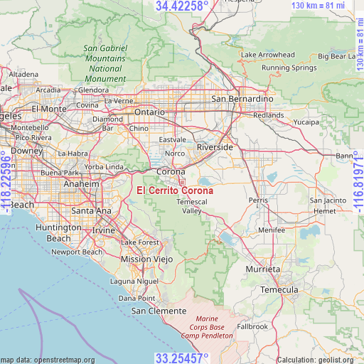
El Cerrito Corona GPS coordinates[2]
33° 50' 26.052" North, 117° 31' 22.188" West
| Map corner | latitude | longitude |
|---|---|---|
| Upper-left | 34.42258°, | -118.22596° |
| Center: | 33.84057°, | -117.52283° |
| Lower-right: | 33.25457°, | -116.81971° |
| Map W x H: | 129.9×129.9 km | = 80.7×80.7mi |
| max Lat: | 71.29058° ⇑81.3% North |
| El Cerrito Corona: | 33.84057° |
| min Lat: | ⇓18.7% South 19.06759° |
| min Long | El Cerrito Coro | max Long |
| -171.73463° | -117.52283° | -66.98998° |
| W 9.6%⇐ | ⇒90.4% E |
Elevation
Elevation of El Cerrito Corona is 264 m = 866 ft, and this is 30.8 m = 101 ft below average elevation for this country.
| Max E: |
3189 m = 10463 ft | 34.6% |
| Avg. | 294.8 m = 967 ft | |
| El Cerrito Corona | 264 m = 866 ft | |
Min E: |
-60 m = -197 ft | 65.4% |
See also: United States elevation on elevation.city.
Geographical zone
El Cerrito Corona is located in North temperate zone (between Tropic of Cancer and the Arctic Circle). Distance of this Northern Tropic circle is 1156.8 km =718.8 mi to South.| Distance of | km | miles | from El Cerrito Corona |
|---|---|---|---|
| North Pole | 6244.3 | 3880 | to North |
| Arctic Circle | 3638.5 | 2260.9 | to North |
| Tropic Cancer | 1156.8 | 718.8 | to South |
| Equator | 3762.7 | 2338 | to South |


Nearby cities:
15 places around El Cerrito Corona: (largest is in red/bold)
• Corona
5.6 km =3.5 mi,  313°
313°
• Eastvale
14.2 km =8.8 mi,  344°
344°
• Foothill Ranch
21.4 km =13.3 mi,  216°
216°
• Glen Avon
19.3 km =12 mi,  10°
10°
• Home Gardens
4.2 km =2.6 mi,  2°
2°
• Jurupa Valley
16.9 km =10.5 mi, 1°
• Mead Valley
21 km =13 mi,  92°
92°
• Norco
10.3 km =6.4 mi,  346°
346°
• Pedley
15.6 km =9.7 mi,  16°
16°
• Portola Hills
20.5 km =12.7 mi,  209°
209°
• Riverside
17.1 km =10.6 mi,  42°
42°
• Rubidoux
20.4 km =12.7 mi,  32°
32°
• Sunnyslope
20.8 km =12.9 mi, 23°
• Trabuco Canyon
20.8 km =12.9 mi,  197°
197°
• Woodcrest
16 km =9.9 mi,  73°
73°
Sources, notices
• [Note1] Compared only with cities in United States existing in our database
• [Src1] Map data: © OpenStreetMap contributors (CC-BY-SA)
• [Src2] Other city data from geonames.org with taken over terms of usage.
• [Src3] Geographical zone / Annual Mean Temperature by Robert A. Rohde @ Wikipedia
