Baker geodata
Baker (California) is a populated place; located in United States in America/Los_Angeles (GMT-7) time zone. With population of 735 people, there are 18355 cities with bigger population in this country. Compared to other cities in United States, 73.8% of cities are located further ↑North; 89.1% of cities are located further →East and 70.3% of cities have lower elevation than Baker. Note1


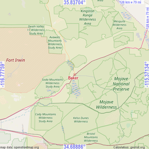
Baker GPS coordinates[2]
35° 15' 53.928" North, 116° 4' 28.056" West
| Map corner | latitude | longitude |
|---|---|---|
| Upper-left | 35.83704°, | -116.77759° |
| Center: | 35.26498°, | -116.07446° |
| Lower-right: | 34.68886°, | -115.37134° |
| Map W x H: | 127.7×127.7 km | = 79.3×79.3mi |
| max Lat: | 71.29058° ⇑73.8% North |
| Baker: | 35.26498° |
| min Lat: | ⇓26.2% South 19.06759° |
| min Long | Baker | max Long |
| -171.73463° | -116.07446° | -66.98998° |
| W 10.9%⇐ | ⇒89.1% E |
Elevation
Elevation of Baker is 287 m = 942 ft, and this is 7.8 m = 26 ft below average elevation for this country.
| Max E: |
3189 m = 10463 ft | 29.7% |
| Avg. | 294.8 m = 967 ft | |
| Baker | 287 m = 942 ft | |
Min E: |
-60 m = -197 ft | 70.3% |
See also: United States elevation on elevation.city.
Geographical zone
Baker is located in North temperate zone (between Tropic of Cancer and the Arctic Circle). Distance of this Northern Tropic circle is 1315.2 km =817.2 mi to South.| Distance of | km | miles | from Baker |
|---|---|---|---|
| North Pole | 6086 | 3781.7 | to North |
| Arctic Circle | 3480.1 | 2162.4 | to North |
| Tropic Cancer | 1315.2 | 817.2 | to South |
| Equator | 3921.1 | 2436.5 | to South |


Nearby cities:
15 places around Baker: (largest is in red/bold)
• Barstow
95.4 km =59.3 mi,  244°
244°
• Barstow Heights
99.6 km =61.9 mi, 243°
• Enterprise
113.2 km =70.3 mi,  41°
41°
• Fort Irwin
55.4 km =34.4 mi,  269°
269°
• Joshua Tree
127.6 km =79.3 mi,  189°
189°
• Lenwood
103.2 km =64.1 mi,  245°
245°
• Lucerne Valley
122.4 km =76.1 mi,  221°
221°
• Pahrump
105.2 km =65.4 mi,  4°
4°
• Paradise
124.8 km =77.5 mi, 42°
• Sandy Valley
73.3 km =45.5 mi,  33°
33°
• Searchlight
107 km =66.5 mi,  77°
77°
• Silver Lakes
129 km =80.2 mi, 243°
• Spring Valley
120 km =74.6 mi, 38°
• Summerlin South
116.2 km =72.2 mi, 35°
• Twentynine Palms
125.6 km =78 mi,  179°
179°
Sources, notices
• [Note1] Compared only with cities in United States existing in our database
• [Src1] Map data: © OpenStreetMap contributors (CC-BY-SA)
• [Src2] Other city data from geonames.org with taken over terms of usage.
• [Src3] Geographical zone / Annual Mean Temperature by Robert A. Rohde @ Wikipedia
