Westmorland geodata
Westmorland (California) is a populated place; located in United States in America/Los_Angeles (GMT-7) time zone. With population of 2,267 people, there are 11172 cities with bigger population in this country. Compared to other cities in United States, 85% of cities are located further ↑North; 89.1% of cities are located further →East and 100% of cities have higher elevation than Westmorland. Note1


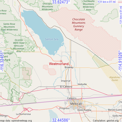
Westmorland GPS coordinates[2]
33° 2' 14.172" North, 115° 37' 16.968" West
| Map corner | latitude | longitude |
|---|---|---|
| Upper-left | 33.62473°, | -116.32451° |
| Center: | 33.03727°, | -115.62138° |
| Lower-right: | 32.44586°, | -114.91826° |
| Map W x H: | 131.1×131.1 km | = 81.5×81.5mi |
| max Lat: | 71.29058° ⇑85% North |
| Westmorland: | 33.03727° |
| min Lat: | ⇓15% South 19.06759° |
| min Long | Westmorland | max Long |
| -171.73463° | -115.62138° | -66.98998° |
| W 10.9%⇐ | ⇒89.1% E |
Elevation
Elevation of Westmorland is -49 m = -161 ft, and this is 343.8 m = 1128 ft below average elevation for this country.
| Max E: |
3189 m = 10463 ft | 100% |
| Avg. | 294.8 m = 967 ft | |
| Westmorland | -49 m = -161 ft | |
Min E: |
-60 m = -197 ft | 0% |
See also: United States elevation on elevation.city.
Geographical zone
Westmorland is located in North temperate zone (between Tropic of Cancer and the Arctic Circle). Distance of this Northern Tropic circle is 1067.5 km =663.3 mi to South.| Distance of | km | miles | from Westmorland |
|---|---|---|---|
| North Pole | 6333.7 | 3935.6 | to North |
| Arctic Circle | 3727.8 | 2316.3 | to North |
| Tropic Cancer | 1067.5 | 663.3 | to South |
| Equator | 3673.4 | 2282.5 | to South |


Nearby cities:
15 places around Westmorland: (largest is in red/bold)
• Borrego Springs
74.3 km =46.2 mi,  289°
289°
• Brawley
10.7 km =6.6 mi,  127°
127°
• Calexico
41.5 km =25.8 mi,  163°
163°
• Calipatria
14 km =8.7 mi,  45°
45°
• Desert Shores
56.4 km =35 mi,  316°
316°
• El Centro
27.8 km =17.3 mi,  168°
168°
• Heber
35.1 km =21.8 mi, 165°
• Holtville
33.7 km =20.9 mi,  138°
138°
• Imperial
21.6 km =13.4 mi, 167°
• Jacumba Hot Springs
70.7 km =43.9 mi,  228°
228°
• Mecca
73.1 km =45.4 mi, 324°
• Niland
24.5 km =15.2 mi,  22°
22°
• Oasis
65.1 km =40.5 mi, 317°
• Salton City
42.6 km =26.5 mi,  313°
313°
• Seeley
27.9 km =17.3 mi,  193°
193°
Sources, notices
• [Note1] Compared only with cities in United States existing in our database
• [Src1] Map data: © OpenStreetMap contributors (CC-BY-SA)
• [Src2] Other city data from geonames.org with taken over terms of usage.
• [Src3] Geographical zone / Annual Mean Temperature by Robert A. Rohde @ Wikipedia
